Forests & woodlands · West Midlands
Dry Sandford Pit
Dry Sandford Pit is a forest or woodland in the United Kingdom.

Wikimedia Commons contributors — see linked file page for photographer and licence licence
Plan your visit
- Typical visit
- 1 h–3 h
- Nearest railway station
- Radley · 5.9 km
- Free entry
- Family-friendly
- Dog-friendly
About
Dry Sandford Pit is a named forest, woodland or nature reserve in the United Kingdom. Coordinates: 51.6926°, -1.3250°. This entry is part of The Great Britain Guide, a free, ad-free, open-data tourist directory.
Photo gallery
Protected designations
- Site of Special Scientific Interest: Cothill Fen SSSI
- Site of Special Scientific Interest: Dry Sandford Pit SSSI
Designations sourced from Natural England open data under OGL v3.
From the Wikipedia article
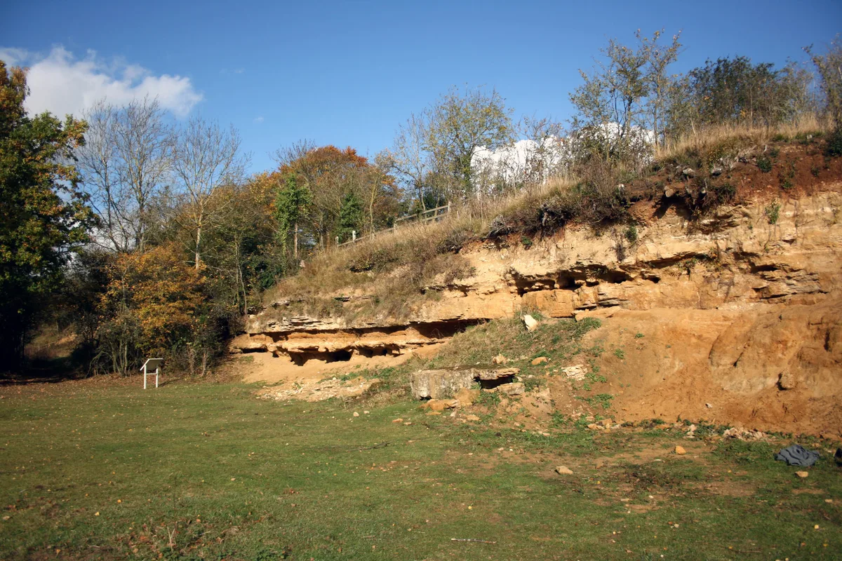
Dry Sandford Pit is a 4.2-hectare (10-acre) biological and geological Site of Special Scientific Interest north-west of Abingdon-on-Thames in Oxfordshire. It is a Geological Conservation Review site and it is managed as a nature reserve by the Berkshire, Buckinghamshire and Oxfordshire Wildlife Trust. This former sand quarry exposes a sequence of limestone rocks laid down in shallow coastal waters during the Oxfordian stage of the Jurassic, around 160 million years ago. It has many fossil ammonites. It has diverse calcareous habitats, including fen, grassland, scrub and heath. It is nationally important entomologically, especially for bees and wasps.
Excerpt from Wikipedia under CC BY-SA 4.0. See the source article linked in Sources below.
- Coordinates
- 51.6926, -1.3250
- County
- Oxfordshire
- District
- Vale of White Horse
- Parish
- St Helen Without
- Postcode
- OX13 6JW
- Parliamentary constituency
- Oxford West and Abingdon
- Nearest railway station
- Radley — 5.9 km
- Official site
- www.bbowt.org.uk
Sources
- osm: w38868288 (ODbL)
- wikipedia: Dry Sandford Pit (CC BY-SA 4.0)
- commons: Quarry Face, Dry Sandford Pit - geograph.org.uk - 2676397.jpg (CC BY-SA 4.0)
Other places nearby
Loading nearby places…
Nearby
 📷 3
📷 3Wildlife reserves · West Midlands
Dry Sandford Pit
Dry Sandford Pit — UK Site of Special Scientific Interest.
 📷 3
📷 3Wildlife reserves · West Midlands
Parsonage Moor
Parsonage Moor — nature reserve in Oxfordshire, England, UK.
📷 3Forests & woodlands · West Midlands
Parsonage Moor
Parsonage Moor is a forest or woodland in the United Kingdom.
📷 3Forests & woodlands · West Midlands
Cothill Fen
Cothill Fen is a forest or woodland in the United Kingdom.
 📷 3
📷 3Forests & woodlands · West Midlands
Hitchcopse Pit
Hitchcopse Pit is a forest or woodland in the United Kingdom.
📷 3Wildlife reserves · West Midlands
Hitchcopse Pit
Hitchcopse Pit is a wildlife reserve in the United Kingdom.
More forests in this region
 📷 3
📷 3Forests & woodlands · West Midlands
Abington Meadows Nature Reserve
Abington Meadows Nature Reserve is a forest or woodland in the United Kingdom.
_(geograph_2935627).jpg?width=1200) 📷 3
📷 3Forests & woodlands · West Midlands
Adderbury Lakes
Adderbury Lakes is a forest or woodland in the United Kingdom.
 📷 3
📷 3Forests & woodlands · West Midlands
Alcott Wood
Alcott Wood is a forest or woodland in the United Kingdom.
 📷 3
📷 3Forests & woodlands · West Midlands
Alvecote Meadows Nature Reserve
Alvecote Meadows Nature Reserve is a forest or woodland in the United Kingdom.
Frequently asked questions
- Where is Dry Sandford Pit?
- Dry Sandford Pit is in Oxfordshire, the West Midlands, United Kingdom (postcode OX13 6JW), in the parish of St Helen Without.
- Is Dry Sandford Pit a protected site?
- Yes — Dry Sandford Pit is part of the Cothill Fen SSSI Site of Special Scientific Interest and the Dry Sandford Pit SSSI Site of Special Scientific Interest.
- Is Dry Sandford Pit free to visit?
- Yes, Dry Sandford Pit is free to enter.
- How do I get to Dry Sandford Pit?
- The nearest railway station is Radley, about 5.9 km away. Drivers can navigate to postcode OX13 6JW.