Forests & woodlands · West Midlands
Dancersend
Dancersend is a forest or woodland in the United Kingdom.

Wikimedia Commons contributors — see linked file page for photographer and licence licence
Plan your visit
- Typical visit
- 1 h–3 h
- Nearest railway station
- Wendover · 3.6 km
- Free entry
- Family-friendly
- Dog-friendly
About
Dancersend is a named forest, woodland or nature reserve in the United Kingdom. Coordinates: 51.7751°, -0.6992°. This entry is part of The Great Britain Guide, a free, ad-free, open-data tourist directory.
Photo gallery
Protected designations
- Site of Special Scientific Interest: Dancersend SSSI
- Area of Outstanding Natural Beauty: Chilterns
Designations sourced from Natural England open data under OGL v3.
From the Wikipedia article
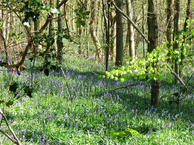
Dancersend is an 81.3-hectare (201-acre) Site of Special Scientific Interest (SSSI) south of Aston Clinton in Buckinghamshire. Part of the site is managed by the Forestry Commission and part by the Berkshire, Buckinghamshire and Oxfordshire Wildlife Trust (BBOWT). The BBOWT's 47 hectare nature reserve, called Dancersend with Pavis Woods, extends into fields west of the SSSI. It is in the Chilterns Areas of Outstanding Natural Beauty. The site was formerly the Dancersend estate of the Rothschild family, who developed it as a nature reserve. It has woodland plantations, unimproved chalk grassland and scrub. The woods have few mature trees as most were felled during the 1940s, but a rich ground flora includes plants associated with ancient woodland, such as hairy brome and wood melick. The site is important for its butterflies and moths, and it has a diverse population of breeding birds. There is access from Bottom Road in Spencersgreen, and by St Leonards Road between Aston Clinton and Chivery.
Excerpt from Wikipedia under CC BY-SA 4.0. See the source article linked in Sources below.
- Coordinates
- 51.7751, -0.6992
- District
- Buckinghamshire
- Parish
- Aston Clinton
- Postcode
- HP23 6LD
- Parliamentary constituency
- Aylesbury
- Nearest railway station
- Wendover — 3.6 km
- Official site
- www.bbowt.org.uk
Sources
- osm: r11151347 (ODbL)
- wikipedia: Dancersend (CC BY-SA 4.0)
- commons: Dancersend 14.JPG (CC BY-SA 4.0)
Other places nearby
Loading nearby places…
Nearby
 📷 3
📷 3Wildlife reserves · West Midlands
Dancersend Nature Reserve
Dancersend Nature Reserve — nature reserve in the United Kingdom.
 📷 3
📷 3Wildlife reserves · West Midlands
Dancersend
Dancersend — SSSI in in Buckinghamshire, England.
 📷 3
📷 3Memorials & monuments · West Midlands
The Chiltern Summit
The Chiltern Summit — a memorial in england-west-midlands, United Kingdom.
Campsites · West Midlands
Hill Farm Campsite
Hill Farm Campsite — a campsite in england west midlands.
 📷 3
📷 3Mountains & hills · West Midlands
Wendover Woods
Wendover Woods — Named summit at 267.5 m.
 📷 3
📷 3Memorials & monuments · West Midlands
Countryside Award 1970
Countryside Award 1970 — a memorial in england-west-midlands, United Kingdom.
More forests in this region
 📷 3
📷 3Forests & woodlands · West Midlands
Abington Meadows Nature Reserve
Abington Meadows Nature Reserve is a forest or woodland in the United Kingdom.
_(geograph_2935627).jpg?width=1200) 📷 3
📷 3Forests & woodlands · West Midlands
Adderbury Lakes
Adderbury Lakes is a forest or woodland in the United Kingdom.
 📷 3
📷 3Forests & woodlands · West Midlands
Alcott Wood
Alcott Wood is a forest or woodland in the United Kingdom.
 📷 3
📷 3Forests & woodlands · West Midlands
Alvecote Meadows Nature Reserve
Alvecote Meadows Nature Reserve is a forest or woodland in the United Kingdom.
Frequently asked questions
- Where is Dancersend?
- Dancersend is in the West Midlands, United Kingdom (postcode HP23 6LD), in the parish of Aston Clinton.
- Is Dancersend a protected site?
- Yes — Dancersend is part of the Dancersend SSSI Site of Special Scientific Interest and the Chilterns National Landscape (AONB).
- Is Dancersend free to visit?
- Yes, Dancersend is free to enter.
- How do I get to Dancersend?
- The nearest railway station is Wendover, about 3.6 km away. Drivers can navigate to postcode HP23 6LD.