Other places · North East England
Crosby Garrett
Crosby Garrett in England North East, United Kingdom.

mauldy — CC BY-SA 2.0 via Wikimedia Commons licence
Plan your visit
- Typical visit
- 1 h–2 h
About
Crosby Garrett is a place of interest in England North East, United Kingdom — drawn from open-data sources for visitor reference. See the linked Wikipedia article for the full description.
Photo gallery
From the Wikipedia article
Crosby Garrett is a hamlet and civil parish in Westmorland and Furness Unitary Authority of Cumbria, England. It was formerly in the county of Westmorland. In the 2011 census Crosby Garrett was grouped with Waitby to give a total of 195. The place-name 'Crosby Garrett' is first attested in a document of 1200, where it appears as Crosseby, and in another of 1206, where it appears as Crossebi Gerard. The first name is Old Scandinavian Krossa-byr, meaning 'village or homestead with crosses'. 'Garrett' is the French personal name 'Gerard', which is ultimately of Germanic origin. In May 2010 the Crosby Garrett Helmet, a copper alloy parade helmet dating to Roman Britain, was discovered near the hamlet by a father and son using a metal detector. The helmet was sold to a private buyer at Christie's later that year for £2.3 million.
Excerpt from Wikipedia under CC BY-SA 4.0. See the source article linked in Sources below.
Background
Description
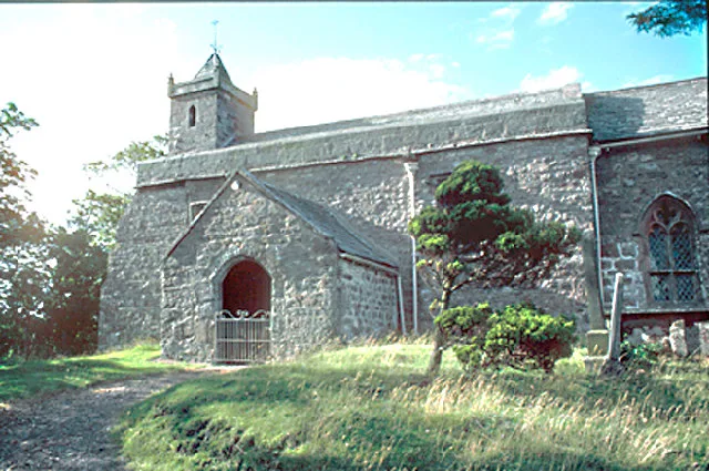
The parish contains no settlements of any size other than the village of Crosby Garrett, and much of the parish is on Crosby Garrett Fell to the south-west of the village. The Settle to Carlisle railway passes through the parish, at the southwestern edge of the village on the 110 yd Crosby Garrett viaduct; the village once had a railway station, Crosby Garrett station, which closed in 1952. The parish church of St. Andrew has an Anglo-Saxon chancel, the remainder of the church dates between the 12th and 15th centuries. In 2010, a major restoration project was undertaken. The highest point in the parish is Nettle Hill at 382 m.
Sourced from Wikipedia under CC BY-SA 4.0.
- Coordinates
- 54.4794, -2.4207
- District
- Westmorland and Furness
- Parish
- Crosby Garrett
- Postcode
- CA17 4PW
- Parliamentary constituency
- Westmorland and Lonsdale
Sources
- wikidata: Q578346 (CC0)
- wikipedia: Crosby Garrett (CC BY-SA 4.0)
Other places nearby
Loading nearby places…
Nearby
📷 5Archaeological sites · North East England
Crosby Garrett Helmet
Crosby Garrett Helmet in England North East, United Kingdom.
 📷 5
📷 5Historic churches · North West England
St Andrew's Church, Crosby Garrett
St Andrew's Church, Crosby Garrett is a historic church in the United Kingdom.
 📷 4
📷 4Heritage railway stations · North East England
Crosby Garrett railway station
Crosby Garrett railway station in England North East, United Kingdom.
 📷 3
📷 3Historic bridges · North West England
Smardale Viaduct
Smardale Viaduct is a historic bridge in the United Kingdom.
 📷 5
📷 5Other places · North East England
Smardale
Smardale in England North East, United Kingdom.
 📷 3
📷 3Historic houses · North West England
Smardale Hall and adjoining buildings
Smardale Hall and adjoining buildings — buildings in Smardale, Cumbria, United Kingdom.
More places in this region
.jpg?width=1200) 📷 3
📷 3Other places · North East England
Stockton Flyer
Stockton Flyer — Public artwork (installation).
 📷 3
📷 3Other places · North East England
Temenos
Temenos — Public artwork (sculpture) by Anish Kapoor.
 📷 5
📷 5Other places · North East England
Appleby Horse Fair
The Appleby Horse Fair, previously known as Appleby New Fair, is an annual gathering of Romani people (Gypsies) and Travellers in Appleby-in-Westmorland in Cumbria, England. The horse fair is held eac
 📷 5
📷 5Other places · North East England
Locomotion No. 1
Locomotion No. 1 (originally named Active) is an early steam locomotive that was built in 1825 by the pioneering railway engineers George and Robert Stephenson at their manufacturing firm, Robert Step
Frequently asked questions
- Where is Crosby Garrett?
- Crosby Garrett is in North East England, in the United Kingdom — coordinates 54.4794°, -2.4207°.