Quarries · North Wales
Cilgwyn quarry
Also known as: Chwarel y Cilgwyn
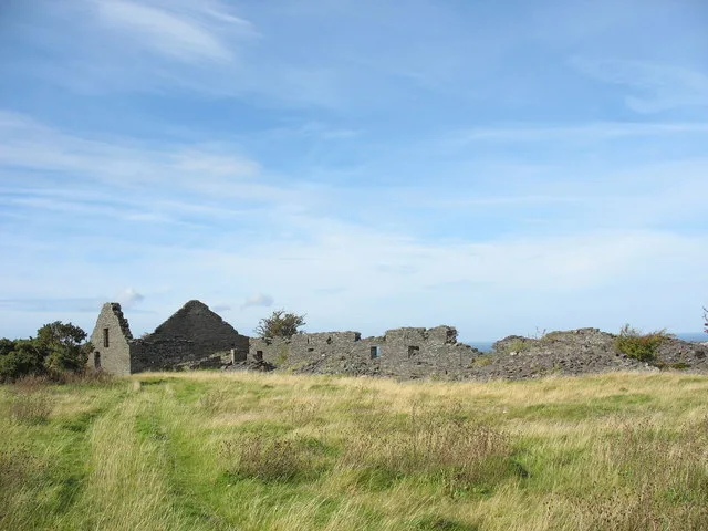
Cilgwyn quarry — former slate quarry in Gwynedd, Wales.

Wikimedia Commons contributors — see linked file page for photographer and licence licence
Plan your visit
- Typical visit
- 45 min–1.5 h
- Nearest railway station
- Tryfan Junction · 5.2 km
About
Cilgwyn quarry is a quarry in the United Kingdom. Wikidata describes it as: "former slate quarry in Gwynedd, Wales". Coordinates: 53.0615°, -4.2387°.
Photo gallery
From the Wikipedia article
Cilgwyn quarry is a slate quarry located on the north edge of the Nantlle Valley, in North Wales. It is one of the earliest slate quarries in Great Britain, having been worked as early as the 12th century. King Edward I of England was reputed to have stayed in a house roofed by Cilgwyn slates during his conquest of Wales. It is one of the major slate quarries in the Nantlle Valley area.
Excerpt from Wikipedia under CC BY-SA 4.0. See the source article linked in Sources below.
Background
History
Quarrying at Cilgwyn dates back to the 12th century. By the end of the 18th century a large number of small pits had grown into a substantial working. The Cilgwyn Quarry Company was formed in 1800 by the Caernarfon solicitor John Evans. By the 1820s it had been taken over by the Cilgwyn and Cefn Du Slate Company, though this company collapsed in 1831. It was then taken over by George Alfred Muskett, a banker from St Albans who served as MP for that city from 1837 to 1841. Muskett's tenure was not successful, and by 1840 the quarry was failing. Many of the quarrymen went unpaid and they resorted to selling slates directly instead of through the company. Muskett fled the country in 1842,…
Description
Cilgwyn was an opencast quarry comprising three main pits: Gloddfa Glitiau to the north-east, Old Cilgwyn to the west and Veingoch to the south-east. Earlier in its history there were a larger number of smaller pits. The mills stood on top of significant waste tips to the south and east of the pits. A tramway north ran from the mills to another waste-tipping site to the north of the quarry at Bryn Hyfryd Terrace.
Sourced from Wikipedia under CC BY-SA 4.0.
- Coordinates
- 53.0615, -4.2387
- District
- Gwynedd
- Parish
- Llandwrog
- Postcode
- LL54 7SF
- Parliamentary constituency
- Dwyfor Meirionnydd
- Nearest railway station
- Tryfan Junction — 5.2 km
Sources
- wikidata: Q16258368 (CC0)
- wikipedia: Cilgwyn quarry (CC BY-SA 4.0)
- commons: CilgwynQuarry.JPG (CC BY-SA 4.0)
Other places nearby
Loading nearby places…
Nearby
 📷 3
📷 3Mountains & hills · North Wales
Mynydd y Cilgwyn
Mynydd y Cilgwyn — a mountain in wales-north, United Kingdom, 347 m.
 📷 3
📷 3Museums · North Wales
Nantlle Valley Slate Quarry Landscape
Nantlle Valley Slate Quarry Landscape — part of the World Heritage site “The Slate Landscape of Northwest Wales” in the United Kingdom.
 📷 5
📷 5Historic churches · North Wales
Y Fron
Y Fron — a church in wales-north, United Kingdom.
 📷 5
📷 5Memorials & monuments · North Wales
Penyrorsedd War Memorial
Penyrorsedd War Memorial — Grade II listed building-listed memorial in wales-north, United Kingdom.
📷 5Historic churches · North Wales
Nantlle
Nantlle () is a small village in the slate quarrying Nantlle Valley in Gwynedd, Wales. It lies on the north shore of Llyn Nantlle Uchaf and is part of the community of Llanllyfni. The population was 2
📷 5Natural landmarks · North Wales
Ysgol Bronyfoel
Ysgol Bronyfoel — a school heritage in wales-north, United Kingdom.
More places in this region
 📷 3
📷 3Quarries · North Wales
Arenig quarry
Arenig quarry — slate quarry near Capel Celyn, Gwynedd (formerly Merionethshire), Wales, United Kingdom.
 📷 3
📷 3Quarries · North Wales
Braich-Ddu quarry
Braich-Ddu quarry — Slate quarry near Trawsfynydd, Wales, United Kingdom.
 📷 3
📷 3Quarries · North Wales
Bryn Hafod-y-Wern quarry
Bryn Hafod-y-Wern quarry — Slate quarry near Llanllechid, Wales, United Kingdom.
 📷 3
📷 3Quarries · North Wales
Bryn quarry
Bryn quarry — Bryn Hall quarry is an old flooded slate quarry near Llanllechid.
Frequently asked questions
- Where is Cilgwyn quarry?
- Cilgwyn quarry is in North Wales, in the United Kingdom — coordinates 53.0615°, -4.2387°. The nearest railway station is Tryfan Junction, around 5.2 km away.