Historic churches · North West England
Castleton, Greater Manchester
Castleton is an area of Rochdale, Greater Manchester, England, 1.2 miles (1.9 km) south-southwest of Rochdale town centre and 8 miles (13 km) north-northeast of the city of Manchester. Historically a

Alan Murray-Rust — CC BY-SA 2.0 via Wikimedia Commons licence
Plan your visit
- Typical visit
- 30 min–1 h
- Free entry
About
Castleton is an area of Rochdale, Greater Manchester, England, 1.2 miles (1.9 km) south-southwest of Rochdale town centre and 8 miles (13 km) north-northeast of the city of Manchester. Historically a part of Lancashire, Castleton's early history is marked by its status as a township within the ancient parish of Rochdale. Prior to merging with the County Borough of Rochdale in 1900, Castleton experienced rapid growth during the 19th century as a mill town in its own right, facilitated for the most part by the construction of the Rochdale Canal which is routed through the area. Castleton's growth was significant; so much so, that for a time it was almost the same size of nearby Rochdale. Located between junctions 19 and 20 of the M62 motorway, Castleton today is a predominantly residential area, with a total population of 9,715, increasing to 10,159 at the 2011 Census.
Photo gallery
From the Wikipedia article
Castleton is an area of Rochdale, Greater Manchester, England, 1.2 miles (1.9 km) south-southwest of Rochdale town centre and 8 miles (13 km) north-northeast of the city of Manchester. Historically a part of Lancashire, Castleton's early history is marked by its status as a township within the ancient parish of Rochdale. Prior to merging with the County Borough of Rochdale in 1900, Castleton experienced rapid growth during the 19th century as a mill town in its own right, facilitated for the most part by the construction of the Rochdale Canal which is routed through the area. Castleton's growth was significant; so much so, that for a time it was almost the same size of nearby Rochdale. Located between junctions 19 and 20 of the M62 motorway, Castleton today is a predominantly residential area, with a total population of 9,715, increasing to 10,159 at the 2011 Census.
Excerpt from Wikipedia under CC BY-SA 4.0. See the source article linked in Sources below.
Background
History
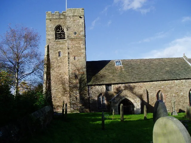
and Grade II listed building in Castleton]] The most ancient known reference to Castleton is found in the Domesday Book (1086). The name suggests a link with a fortification; the Castleton area was the site of Rochdale Castle. The castle is believed to have been located on the south bank of the River Roch, which runs through Castleton. During the 13th century, Castleton was known as Castletown, or Castle Town. Approximately 60 acres of land (four bovates) were endowed to Stanlaw Abbey in the late years of Roger de Lacy (1170–1211) for the benefit of its Cistercian monastic community. Back around the time the canal was built, Castleton was known as Blue Pits Village, because of the blue clay…
Sourced from Wikipedia under CC BY-SA 4.0.
- Coordinates
- 53.5907, -2.1737
- District
- Rochdale
- Parish
- Rochdale, unparished area
- Postcode
- OL11 2QD
- Parliamentary constituency
- Heywood and Middleton North
Sources
- wikipedia: Castleton, Greater Manchester (CC BY-SA 4.0)
Other places nearby
Loading nearby places…
Nearby
 📷 3
📷 3Historic bridges · North West England
Rochdale Canal Lock Number 52 And Towpath Bridge
Rochdale Canal Lock Number 52 And Towpath Bridge — Grade II listed building-listed bridge in england-north-west, United Kingdom.
 📷 3
📷 3Theatres · North West England
Ideal Cinema
Ideal Cinema in England North West, United Kingdom.
Hotels · North West England
Norton Grange Hotel
Norton Grange Hotel — a hotel in england north west.
 📷 3
📷 3Theatres · North West England
Odeon Rochdale
Odeon Rochdale in England North West, United Kingdom.
 📷 3
📷 3Memorials & monuments · North West England
Thornham Parish War Memorial
Thornham Parish War Memorial — Grade II listed building-listed memorial in england-north-west, United Kingdom.
 📷 5
📷 5Natural landmarks · North West England
Balderstone Technology College
Balderstone Technology College — a school heritage in england-north-west, United Kingdom.
More places in this region
 📷 3
📷 3Historic churches · North West England
All Hallows Church, Great Mitton
All Hallows Church, Great Mitton — church in the village of Great Mitton, Lancashire, England, UK.
 📷 3
📷 3Historic churches · North West England
All Saints Church, Barnacre
All Saints Church, Barnacre — grade II listed church in Barnacre-with-Bonds, Wyre, Lancashire, England, UK.
 📷 3
📷 3Historic churches · North West England
All Saints Church, Becconsall
All Saints Church, Becconsall — church in United Kingdom.
 📷 3
📷 3Historic churches · North West England
All Saints Church, Burton in Lonsdale
All Saints Church, Burton in Lonsdale — church in Burton in Lonsdale, North Yorkshire, England, UK.
Frequently asked questions
- Where is Castleton, Greater Manchester?
- Castleton, Greater Manchester is in North-West England, United Kingdom (postcode OL11 2QD), in the parish of Rochdale, unparished area.
- Is Castleton, Greater Manchester free to visit?
- Yes, Castleton, Greater Manchester is free to enter.
- How do I get to Castleton, Greater Manchester?
- Drivers can navigate to postcode OL11 2QD. It sits within the Heywood and Middleton North parliamentary constituency.