Towns & cities · Central Scotland
Carstairs
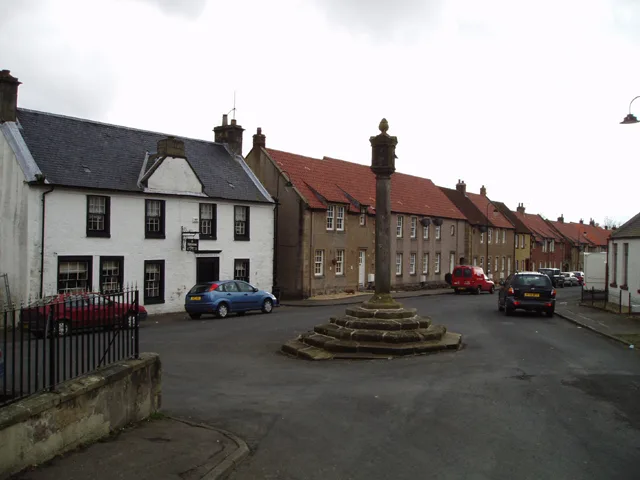
Carstairs — village in South Lanarkshire, Scotland, UK.

Wikimedia Commons contributors — see linked file page for photographer and licence licence
Plan your visit
- Typical visit
- 3 h–6 h
- Nearest railway station
- Carstairs · 1.5 km
- Free entry
- Family-friendly
- Dog-friendly
About
Carstairs is a town, city, village or settlement in the United Kingdom. Recent population estimates put it at around 880 people. Wikidata describes it as: "village in South Lanarkshire, Scotland, UK". Coordinates: 55.6960°, -3.6910°.
Photo gallery
From the Wikipedia article
Carstairs (, Scottish Gaelic: Caisteal Tarrais) is a village in South Lanarkshire, Scotland, located 5 miles (8 kilometres) east of the county town of Lanark. The West Coast Main Line provides service to Carstairs railway station, which is served by the Caledonian Sleeper, ScotRail and TransPennine Express services. Carstairs is best known as the location of the State Hospital. Carstairs is applied to the places Carstairs Village and the village of Carstairs Junction where the railway station is situated. The two places are two completely different villages divided by 1 mile (1.5 kilometres) of land, a parkland area (Monteith Park) and the railway line. Carstairs Village has massively expanded since 2007 with the building of Millwood Estate.
Excerpt from Wikipedia under CC BY-SA 4.0. See the source article linked in Sources below.
Background
History
A Roman fort was built at Castledyke in the first and second century AD. A later military castle occupied the site from at least the 12th century, known as Carstairs Castle. It has since been lost, but some underground remains have been found. A parish school was opened in 1619, and by 1754 William Roy recorded a sizeable farming village on the Lanark road to Carnwath and Edinburgh. Carstairs was made a burgh of barony in 1765. The mansion of Carstairs House was built in 1821–24 for Henry Montheith. 1848 saw the building of a railway station by the Caledonian Railway. By 1895 there was an inn and post office at the village. During the 1920s, the Ministry of Labour acquired Lampits Farm,…
Sourced from Wikipedia under CC BY-SA 4.0.
- Coordinates
- 55.6960, -3.6910
- District
- South Lanarkshire
- Postcode
- ML11 8QQ
- Parliamentary constituency
- Dumfriesshire, Clydesdale and Tweeddale
- Population
- 880
- Nearest railway station
- Carstairs — 1.5 km
- Official site
- www.southlanarkshire.gov.uk
Sources
- wikidata: Q1009254 (CC0)
- wikipedia: Carstairs (CC BY-SA 4.0)
- commons: Carstairs Village Green - geograph.org.uk - 119801.jpg (CC BY-SA 4.0)
Other places nearby
Loading nearby places…
Nearby
 📷 3
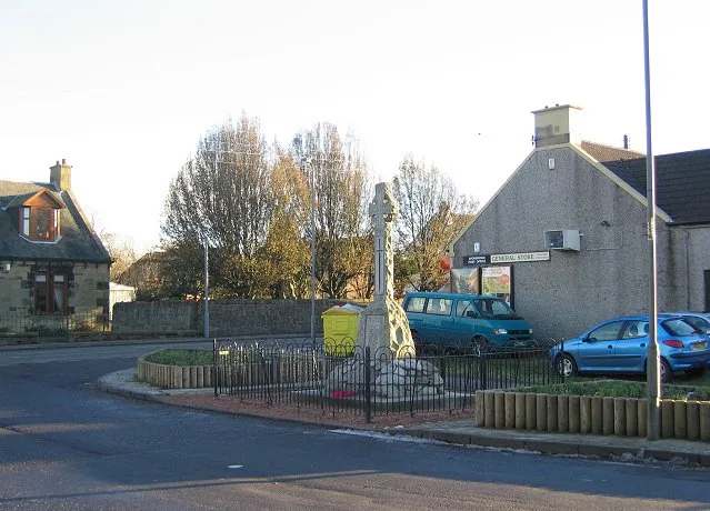
📷 3Memorials & monuments · Central Scotland
Carstairs Village War Memorial
Carstairs Village War Memorial — a memorial in scotland-central, United Kingdom.
 📷 5
📷 5Historic churches · Central Scotland
Carstairs Church
Carstairs Church — category B listed building-listed church in scotland-central, United Kingdom.
 📷 3
📷 3Cemeteries · Central Scotland
Carstairs Avenue Road Cemetery
Carstairs Avenue Road Cemetery is a cemetery in the United Kingdom.
 📷 3
📷 3Castles · Central Scotland
Carstairs Castle
Carstairs Castle — castle in South Lanarkshire, Scotland, UK.
Caravan parks · Central Scotland
Newhouse Park Farm
Newhouse Park Farm — a caravan park in scotland central.
 📷 3
📷 3Historic houses · Central Scotland
Carstairs House
Carstairs House is a historic house in the United Kingdom.
More towns in this region
 Flagship📷 3
Towns & cities · Central Scotland
Airth
Airth — village in Falkirk, Scotland, UK.
 Flagship📷 5
Towns & cities · Central Scotland
Avonbridge
Avonbridge — village in Falkirk, Scotland, UK.
 Flagship📷 3
Towns & cities · Central Scotland
Banknock
Banknock — village in Falkirk, Scotland, UK.
 Flagship📷 3
Towns & cities · Central Scotland
Dundee
Dundee — city in Scotland, UK.
Frequently asked questions
- Where is Carstairs?
- Carstairs is in central Scotland, United Kingdom (postcode ML11 8QQ).
- Is Carstairs free to visit?
- Yes, Carstairs is free to enter.
- How do I get to Carstairs?
- The nearest railway station is Carstairs, about 1.5 km away. Drivers can navigate to postcode ML11 8QQ.