Historic bridges · Northern Ireland
Carrick-a-rede Rope Bridge
Carrick-a-rede Rope Bridge is a historic bridge in the United Kingdom.

Wikimedia Commons contributors — see linked file page for photographer and licence licence
Plan your visit
- Typical visit
- 15 min–30 min
- Free entry
- Family-friendly
- Dog-friendly
- Limited wheelchair access
About
Carrick-a-rede Rope Bridge is a named historic bridge in the United Kingdom. Records date its origin to 2008. Coordinates: 55.2395°, -6.3324°.
Photo gallery
From the Wikipedia article
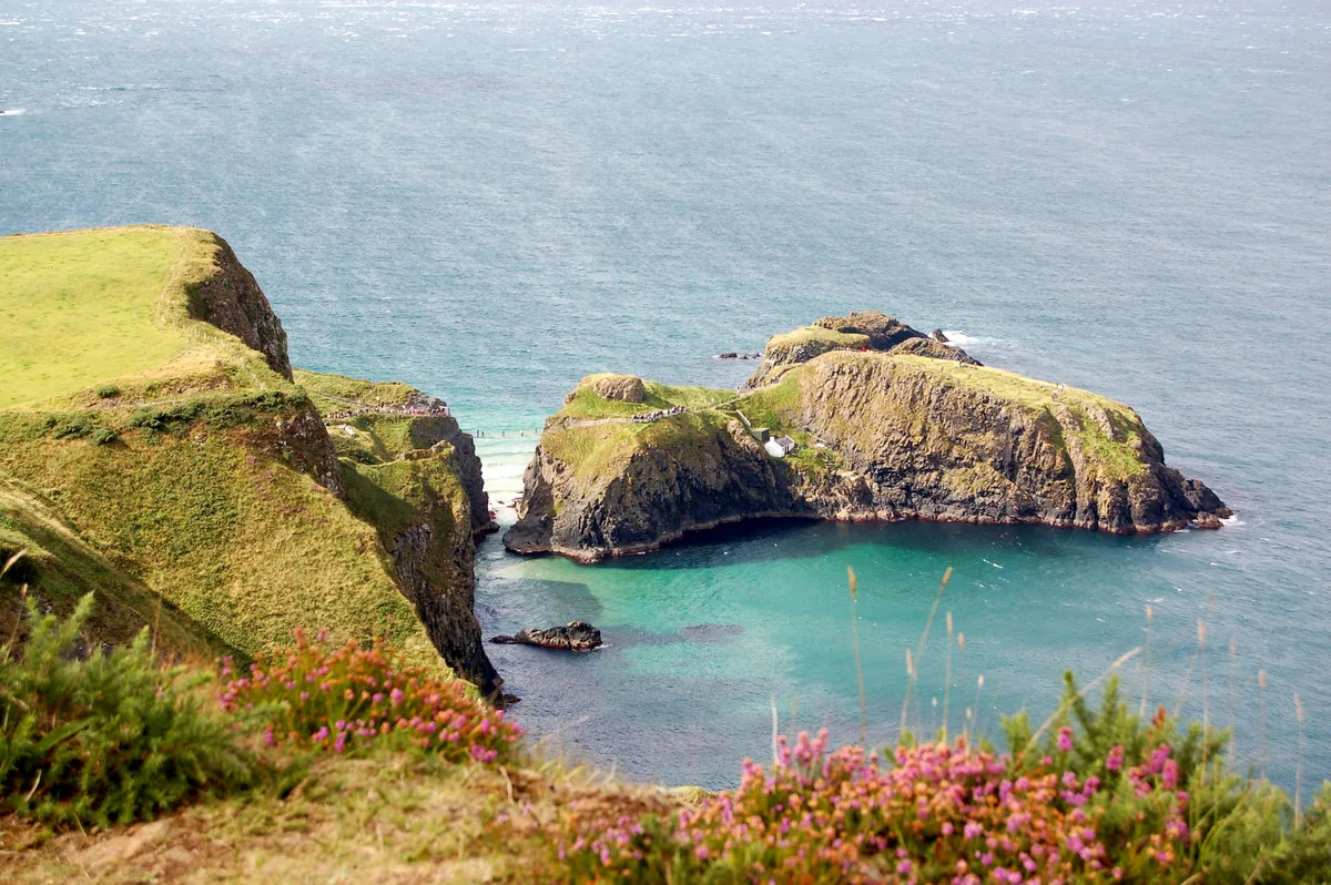
The Carrick-a-Rede Rope Bridge (locally pronounced carrick-a-reed) is a rope bridge near Ballintoy in County Antrim, Northern Ireland. The bridge links the mainland to the tiny island of Carrickarede (from Irish Carraig a' Ráid, meaning 'rock of the casting'). It spans 20 metres (66 ft) and is 30 metres (98 ft) above the rocks below. The bridge is mainly a tourist attraction and is owned and maintained by the National Trust. In 2018, the bridge had 485,736 visitors. Since 2009, the bridge has been open all year round (subject to weather) and people may cross it for a £14 to £15 (adult) fee.
Excerpt from Wikipedia under CC BY-SA 4.0. See the source article linked in Sources below.
Background
History
1890-1900]] It is thought salmon fishermen have been building bridges to the island for over 350 years. It has taken many forms over the years. In the 1970s it had only one handrail and large gaps between the slats. A new bridge, tested up to ten tonnes, was built with the help of local climbers and abseilers in 2000. Another was built in 2004 and offered visitors and fishermen alike a much safer passage to the island. The current wire rope and Douglas fir bridge was made by Heyn Construction in Belfast and raised early in 2008 at a cost of over £16,000. There have been many instances where visitors, unable to face the walk back across the bridge, have had to be taken off the island by…
Description
There are views of Rathlin Island and Scotland from the area. The site and surrounding area is designated an Area of Special Scientific Interest for its unique geology, flora, and fauna. Underneath there are large caves, which once served as home for boat builders and as shelter during stormy weather.
Visiting
A plate of this bridge (Artist: Thomas Mann Baynes – Engraved by: J. Davies) appeared in Fisher's Drawing Room Scrap Book, 1832, accompanied by a poetical illustration by Letitia Elizabeth Landon (L. E. L.) referring to a gentleman who is supposed to have lived on the island as a hermit at one time (possibly a rebel who had fled out of Scotland). Seamus Heaney describes the bridge in his 1978 poem A Postcard from North Antrim: <poem style="margin-left: 2em;"> A lone figure is waving From the thin line of a bridge Of ropes and slates, slung Dangerously out between The cliff-top and the pillar rock. </poem>
Sourced from Wikipedia under CC BY-SA 4.0.
- Coordinates
- 55.2395, -6.3324
- District
- Causeway Coast and Glens
- Postcode
- BT54 6LS
- Parliamentary constituency
- North Antrim
- Established
- 2008
- Opening
- 2008 (current bridge)
Sources
- osm: w28524490 (ODbL)
- wikipedia: Carrick-a-Rede Rope Bridge (CC BY-SA 4.0)
- commons: Carrick-a-rede rope bridge.jpg (CC BY-SA 4.0)
Featured in this guide
Other places nearby
Loading nearby places…
Nearby
 📷 3
📷 3Islands · Northern Ireland
Carrick-a-Rede
Carrick-a-Rede — island in County Antrim, Northern Ireland.
 📷 3
📷 3Memorials & monuments · Northern Ireland
Lime Kiln, Carrick-a-rede
Lime Kiln, Carrick-a-rede is a memorial in the United Kingdom.
Vineyards · Northern Ireland
Larrybane
Larrybane — a UK vineyard in northern ireland, producing English or Welsh wine from cool-climate grape varieties.
 📷 5
📷 5Towns & cities · Northern Ireland
Ballintoy
Ballintoy — village in County Antrim, Northern Ireland.
Hostels · Northern Ireland
Sheep Island View Hostel
Sheep Island View Hostel — a hostel in northern ireland.
 📷 3
📷 3Archaeological sites · Northern Ireland
Knockanargus
Knockanargus — a archaeological in northern-ireland, United Kingdom.
Other bridges from this era
 📷 5
📷 5Historic bridges · London
Affection
Affection — Public artwork (sculpture).
.JPG?width=1200) 📷 5
📷 5Historic bridges · London
Albert Bridge
Albert Bridge is a historic bridge in the United Kingdom.
.jpg?width=1200) 📷 5
📷 5Historic bridges · London
Blue Bridge
Blue Bridge is a historic bridge in the United Kingdom.
 📷 5
📷 5Historic bridges · London
Catford Cat
Catford Cat — Public artwork (sculpture).
More bridges in this region
 📷 3
📷 3Historic bridges · Northern Ireland
Albert Bridge
Albert Bridge is a historic bridge in the United Kingdom.
 📷 3
📷 3Historic bridges · Northern Ireland
Antrim Road
Antrim Road is a historic bridge in the United Kingdom.
 📷 3
📷 3Historic bridges · Northern Ireland
Arthur Road
Arthur Road is a historic bridge in the United Kingdom.
 📷 3
📷 3Historic bridges · Northern Ireland
Ballinlea Road
Ballinlea Road is a historic bridge in the United Kingdom.
Frequently asked questions
- Where is Carrick-a-rede Rope Bridge?
- Carrick-a-rede Rope Bridge is in Northern Ireland, United Kingdom (postcode BT54 6LS).
- When was Carrick-a-rede Rope Bridge built?
- Built or established in 2008.
- Who owns Carrick-a-rede Rope Bridge?
- Carrick-a-rede Rope Bridge is owned by | maint =.
- Is Carrick-a-rede Rope Bridge free to visit?
- Yes, Carrick-a-rede Rope Bridge is free to enter.
- How do I get to Carrick-a-rede Rope Bridge?
- Drivers can navigate to postcode BT54 6LS. It sits within the North Antrim parliamentary constituency.