Reservoirs & lochs · North East England
Burnhope Burn
Burnhope Burn in England North East, United Kingdom.

Oliver Dixon — CC BY-SA 2.0 via Wikimedia Commons licence
Plan your visit
- Typical visit
- 1 h–2.5 h
- Free entry
- Dog-friendly
About
Burnhope Burn is a place of interest in England North East, United Kingdom — drawn from open-data sources for visitor reference. See the linked Wikipedia article for the full description.
Photo gallery
From the Wikipedia article
Burnhope Burn is a Site of Special Scientific Interest in the Wear Valley district of north County Durham, England. It consists of a 12.6-acre (5.1 ha) area of woodland, carr, fen and mire in the valley of Burnhope Burn, just below the dam of the Derwent Reservoir, a mile (1.6 km) north-east of the village of Edmundbyers. It contains a range of habitats that are characteristic of poorly drained soils and that are rare or local in County Durham; such as smooth-stalked sedge (Carex levigata), bogbean (Menyanthes) and globeflower (Trollius). In a small basin-mire in the northern part of the site, there are abundant communities of a number of species that have a localised distribution elsewhere in the county.
Excerpt from Wikipedia under CC BY-SA 4.0. See the source article linked in Sources below.
- Coordinates
- 54.8517, -1.9556
- District
- Northumberland
- Parish
- Shotley Low Quarter
- Postcode
- DH8 9TT
- Parliamentary constituency
- Hexham
- Established
- 1987
- Official site
- magic.defra.gov.uk
Sources
- wikidata: Q4999765 (CC0)
- wikipedia: Burnhope Burn (CC BY-SA 4.0)
Other places nearby
Loading nearby places…
Nearby
Caravan parks · Scottish Lowlands
Struthers Farm Caravan Site
Struthers Farm Caravan Site — a caravan park in scotland lowlands.
Hostels · Scottish Lowlands
Edmundbyers Youth Hostel at Low House Haven
Edmundbyers Youth Hostel at Low House Haven — a hostel in scotland lowlands. Brand: Youth Hostels Association.
 📷 5
📷 5Reservoirs & lochs · North East England
Edmundbyers
Edmundbyers in England North East, United Kingdom.
 📷 4
📷 4Other places · North East England
Muggleswick
Muggleswick in England North East, United Kingdom.
 📷 3
📷 3Historic houses · Scottish Lowlands
Remains of Monastic Grange
Remains of Monastic Grange — a historic house in scotland-lowlands, United Kingdom.
 📷 3
📷 3Memorials & monuments · Scottish Lowlands
Muggleswick War Memorial
Muggleswick War Memorial — Grade II listed building-listed memorial in scotland-lowlands, United Kingdom.
More places in this region
 Flagship📷 3
Reservoirs & lochs · North East England
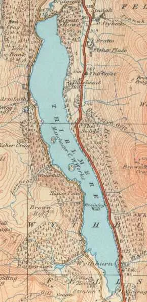
Thirlmere
Thirlmere — reservoir in the United Kingdom.
 📷 2
📷 2Reservoirs & lochs · North East England
Balderhead Reservoir
Balderhead Reservoir — reservoir in County Durham, England, UK.
 📷 3
📷 3Reservoirs & lochs · North East England
Blackton Reservoir
Blackton Reservoir — reservoir in County Durham, England, UK.
 📷 5
📷 5Reservoirs & lochs · North East England
Cogra Moss
Cogra Moss — reservoir in Cumbria, England, UK.
Frequently asked questions
- Where is Burnhope Burn?
- Burnhope Burn is in North-East England, United Kingdom (postcode DH8 9TT), in the parish of Shotley Low Quarter.
- When was Burnhope Burn built?
- Built or established in 1987.
- How do I get to Burnhope Burn?
- Drivers can navigate to postcode DH8 9TT. It sits within the Hexham parliamentary constituency.