Museums · East of England
Burnham-on-Crouch
Burnham-on-Crouch is a town and civil parish in the Maldon District of Essex, in the East of England; it lies on the north bank of the River Crouch. It is one of Britain's leading places for yachting.

John Baker — CC BY-SA 2.0 via Wikimedia Commons licence
Plan your visit
- Typical visit
- 1.5 h–3 h
- Best time of year
- Year-round
- Family-friendly
- Limited wheelchair access
About
Burnham-on-Crouch is a town and civil parish in the Maldon District of Essex, in the East of England; it lies on the north bank of the River Crouch. It is one of Britain's leading places for yachting. The civil parish extends 5 miles (8 km) east of the town to the mouth of the River Crouch. It includes the hamlets of Creeksea and Ostend west of the town; Stoneyhills to the north; and Dammer Wick, West Wick and East Wick east of the town. At the 2021 census the parish had a population of 8,852 and the Burnham-on-Crouch built up area had a population of 7,805.
Photo gallery
From the Wikipedia article
Burnham-on-Crouch is a town and civil parish in the Maldon District of Essex, in the East of England; it lies on the north bank of the River Crouch. It is one of Britain's leading places for yachting. The civil parish extends 5 miles (8 km) east of the town to the mouth of the River Crouch. It includes the hamlets of Creeksea and Ostend west of the town; Stoneyhills to the north; and Dammer Wick, West Wick and East Wick east of the town. At the 2021 census the parish had a population of 8,852 and the Burnham-on-Crouch built up area had a population of 7,805.
Excerpt from Wikipedia under CC BY-SA 4.0. See the source article linked in Sources below.
Background
History
The name Burnham derives from the Old English burnahām meaning 'settlement by a stream'. According to the Domesday Book of 1086, Burnham was held in 1066 by a thegn called Alward and 10 free men. After 1066 it was acquired by a Norman called Tedric Pointel of Coggeshall whose overlord was Ralph Baynard. Historically, it has benefited from its location on the coast – first as a ferry port, later as a fishing port known for its oyster beds, and most recently as a centre for yachting. meaning it has facilities that are uncommon in small towns, such as a cinema, a laundrette, a post office, 22 licensed drinking establishments and three pharmacies. Burnham played a significant role in both world…
Sourced from Wikipedia under CC BY-SA 4.0.
- Coordinates
- 51.6284, 0.8145
- County
- Essex
- District
- Maldon
- Parish
- Burnham-on-Crouch
- Postcode
- CM0 8HH
- Parliamentary constituency
- Maldon
Sources
- wikipedia: Burnham-on-Crouch (CC BY-SA 4.0)
Other places nearby
Loading nearby places…
Nearby
 📷 4
📷 4Theatres · East of England
Rio Cinema
Rio Cinema in England East, United Kingdom.
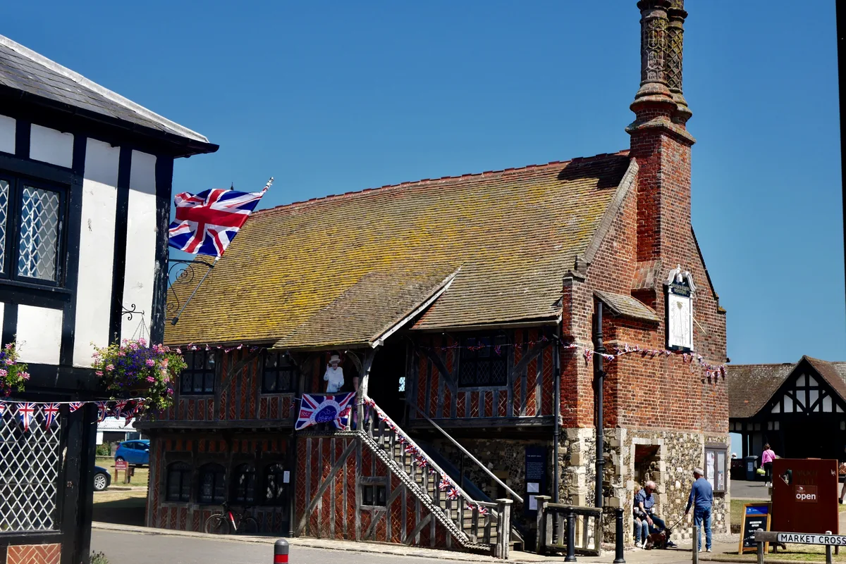
📷 5Museums · East of England
Burnham-on-Crouch & District Museum
The Burnham-on-Crouch and District Museum, located in Burnham-on-Crouch, Essex, is a registered charity run by members of the Burnham History Society, aiming to reflect the history and development of
📷 3Museums · East of England
Burnham-on-Crouch and District Museum
Burnham-on-Crouch and District Museum — a museum in england-east, United Kingdom.
 📷 5
📷 5Memorials & monuments · East of England
War Memorial
War Memorial is a memorial in the United Kingdom.
📷 3Memorials & monuments · East of England
Burnham-on-Crouch War Memorial
Burnham-on-Crouch War Memorial — Grade II listed building-listed memorial in england-east, United Kingdom.
Hotels · East of England
Ye Olde White Harte Hotel
Ye Olde White Harte Hotel — a hotel in england east.
More museums in this region
 📷 3
📷 3Museums · East of England
Aldeburgh Museum
Aldeburgh Museum — independent Museum in the East of England, United Kingdom.
 📷 3
📷 3Museums · East of England
Alfred Corry Lifeboat Museum
Alfred Corry Lifeboat Museum — UK museum in Southwold, East Suffolk, England.
 📷 3
📷 3Museums · East of England
Ancient House Museum
Ancient House Museum — Grade I listed building in Thetford, Breckland District, Norfolk, England, United Kingdom.
 📷 3
📷 3Museums · East of England
Beccles and District Museum
Beccles and District Museum — Museum in United Kingdom.
Frequently asked questions
- Where is Burnham-on-Crouch?
- Burnham-on-Crouch is in East of England, in the United Kingdom — coordinates 51.6284°, 0.8145°.
- Is Burnham-on-Crouch wheelchair accessible?
- Partially — OpenStreetMap notes limited wheelchair access at Burnham-on-Crouch. Check ahead for specific facilities.