Mountains & hills · Scottish Lowlands
Broad Law
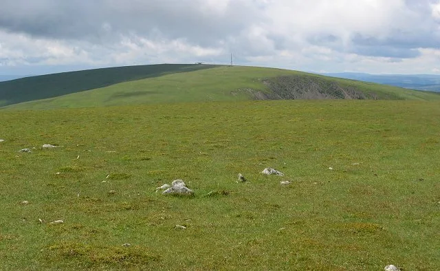
Broad Law — Named summit at 840 m.

Wikimedia Commons contributors — see linked file page for photographer and licence licence
Plan your visit
- Typical visit
- 3 h–8 h
- Best time of year
- Late spring – early autumn (May–Oct)
- Free entry
- Dog-friendly
About
Broad Law is a named summit in the United Kingdom. Wikidata describes it as: "Named summit at 840 m.". Coordinates: 55.4983°, -3.3529°.
Photo gallery
From the Wikipedia article
Broad Law is a hill in the Manor Hills range, part of the Southern Uplands of Scotland. The second-highest point in the Southern Uplands and the highest point in the Scottish Borders, it has an elevation of 840 metres, a prominence of 653 metres (and thus is a "major") and an isolation of 81 kilometres. It is only 3 m (10 ft) lower than its parent, Merrick. Like many of its neighbours it is smooth, rounded and grassy, although the surrounding glens have very steep sides — country somewhat akin to the Cheviots or the Howgill Fells. The hill is most easily climbed from the Megget Stane to the south, beginning at an elevation of 452 m (1,483 ft), but is also frequently climbed from the villages near its base, or as part of a long, 50 km (30 mi) trek across the local area between the towns of Peebles and Moffat. On the summit is the highest VOR beacon in the UK, and also a radio tower. The summit of Broad Law is also the highest point (county top) of the historic county of Peeblesshire. It is also sometimes (erroneously) given as the county top of Selkirkshire. This is because in 1891, the area of Megget (a detached part of Lyne parish in Peeblesshire) was transferred to Yarrow parish in Selkirkshire. The administrative "county" boundary of Peeblesshire and Selkirkshire thus temporarily crossed Broad Law summit between 1891 and 1974. However, the historic county boundary remained several kilometres to the east, where Dun Rig is the county top of Selkirkshire.
Excerpt from Wikipedia under CC BY-SA 4.0. See the source article linked in Sources below.
- Coordinates
- 55.4983, -3.3529
- Address
- Scottish Borders, Scotland
Sources
- osm: n345150406 (ODbL)
- wikipedia: Broad Law (CC BY-SA 4.0)
- commons: Cramalt Craig view to Broad Law.jpg (CC BY-SA 4.0)
Other places nearby
Loading nearby places…
Nearby
 📷 3
📷 3Natural landmarks · Scottish Lowlands
Broad Law
Broad Law — 840m high mountain in Scottish Borders, Scotland, UK.
 📷 3
📷 3Reservoirs & lochs · Scottish Lowlands
Talla Reservoir
Talla Reservoir — artificial lake in Scottish Borders, Scotland, UK, on Talla Water.
Vineyards · Central Scotland
The Chester, enclosure 180m NE of Glenrusko
The Chester, enclosure 180m NE of Glenrusko — a UK vineyard in scotland central, producing English or Welsh wine from cool-climate grape varieties.
 📷 3
📷 3Historic bridges · Central Scotland
Glenrusco Bridge
Glenrusco Bridge is a historic bridge in the United Kingdom.
 📷 5
📷 5Historic churches · Central Scotland
Tweedsmuir Parish Church
Tweedsmuir Parish Church — category B listed building-listed church in scotland-central, United Kingdom.
 📷 5
📷 5Historic bridges · Central Scotland
Polmood Bridge
Polmood Bridge — category C listed building-listed bridge in scotland-central, United Kingdom.
More mountains in this region
 📷 3
📷 3Mountains & hills · Scottish Lowlands
Andrewhinney Hill
Andrewhinney Hill — Named summit at 677 m.
 📷 3
📷 3Mountains & hills · Scottish Lowlands
Arbory Hill
Arbory Hill — Named summit at 429 m.
 📷 3
📷 3Mountains & hills · Scottish Lowlands
Auchenton Hill ( East Mount Lowther)
Auchenton Hill ( East Mount Lowther) — Named summit at 631 m.
 📷 3
📷 3Mountains & hills · Scottish Lowlands
Bakestall
Bakestall — Named summit at 673.5 m.
Frequently asked questions
- Where is Broad Law?
- Broad Law is in Scottish Lowlands, in the United Kingdom — coordinates 55.4983°, -3.3529°.
- Is Broad Law free to visit?
- Yes — admission to Broad Law is free.