Mountains & hills · South East England
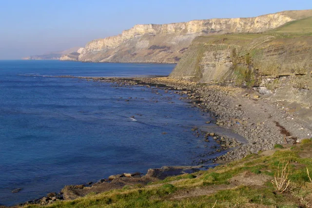
Brandy Bay
Brandy Bay — bay in Dorset, England, UK.

Wikimedia Commons contributors — see linked file page for photographer and licence licence
Plan your visit
- Typical visit
- 3 h–8 h
- Best time of year
- Late spring – early autumn (May–Oct)
- Nearest railway station
- Norden · 7.4 km
- Free entry
- Dog-friendly
About
Brandy Bay is a named summit in the United Kingdom. Part of English Channel. Wikidata describes it as: "bay in Dorset, England, UK". Coordinates: 50.6140°, -2.1562°.
Photo gallery
Protected designations
- Site of Special Scientific Interest: South Dorset Coast SSSI
- Area of Outstanding Natural Beauty: Dorset
Designations sourced from Natural England open data under OGL v3.
From the Wikipedia article
Brandy Bay is a small secluded southwest-facing bay, with an oil shale and shingle beach immediately below Gad Cliff and Tyneham Cap, to the east of Worbarrow Bay and to the west of Hobarrow Bay on the south coast of the Isle of Purbeck, in Dorset, England. Brandy Bay is located about 1 kilometre (0.62 mi) southeast of the ghost village Tyneham, 6 kilometres (3.7 mi) south of Wareham and about 16 kilometres (9.9 mi) west of Swanage. It is on the Jurassic Coast World Heritage Site and in the Dorset National Landscape area.
Excerpt from Wikipedia under CC BY-SA 4.0. See the source article linked in Sources below.
Background
History
Brandy Bay once had a Roman settlement, but the name derives from the frequent smuggling activities that were taking place here during the 17th and 18th centuries.
Sourced from Wikipedia under CC BY-SA 4.0.
- Coordinates
- 50.6140, -2.1562
- District
- Dorset
- Parish
- Kimmeridge
- Postcode
- BH20 5PF
- Parliamentary constituency
- South Dorset
- Nearest railway station
- Norden — 7.4 km
Sources
- wikidata: Q15204175 (CC0)
- wikipedia: Brandy Bay, Dorset (CC BY-SA 4.0)
- commons: Gad Cliff and Brandy Bay - geograph.org.uk - 628770.jpg (CC BY-SA 4.0)
Other places nearby
Loading nearby places…
Nearby
 📷 5
📷 5Mountains & hills · South East England
Hobarrow Bay
Hobarrow Bay — bay in Dorset, England.
 📷 5
📷 5Stately homes · South East England
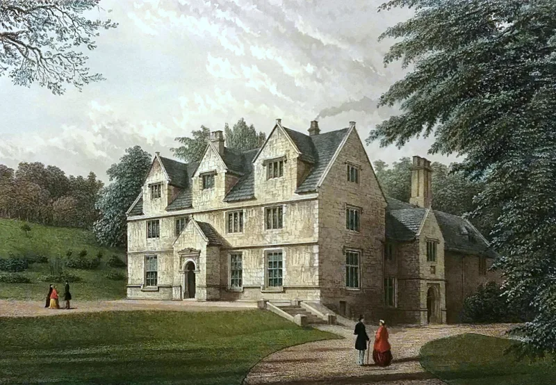
Tyneham House
Tyneham House — house in Tyneham, Dorset, England, UK.
 📷 5
📷 5Museums · South East England
Tyneham
Tyneham — a museum in england-south-east, United Kingdom.
 📷 5
📷 5Historic houses · South East England
Tyneham Post Office
Tyneham Post Office — a historic house in england-south-east, United Kingdom.
📷 5Historic houses · South East England
Gwyle Cottages
Gwyle Cottages — a historic house in england-south-east, United Kingdom.
 📷 5
📷 5Museums · South East England
Tyneham School
Tyneham School — a museum in england-south-east, United Kingdom.
More mountains in this region
 📷 5
📷 5Mountains & hills · South East England
Alum Bay
Alum Bay is a mountain or hill in the United Kingdom.
 📷 5
📷 5Mountains & hills · South East England
Arish Mell
Arish Mell — bay in Dorset, England.
 📷 5
📷 5Mountains & hills · South East England
Balaclava Bay
Balaclava Bay — bay in Dorset, England.
 📷 5
📷 5Mountains & hills · South East England
Balch Cave
Balch Cave — Cave in Somerset, England.
Frequently asked questions
- Where is Brandy Bay?
- Brandy Bay is in South-East England, United Kingdom (postcode BH20 5PF), in the parish of Kimmeridge.
- Is Brandy Bay a protected site?
- Yes — Brandy Bay is part of the South Dorset Coast SSSI Site of Special Scientific Interest and the Dorset National Landscape (AONB).
- Is Brandy Bay free to visit?
- Yes, Brandy Bay is free to enter.
- How do I get to Brandy Bay?
- The nearest railway station is Norden, about 7.4 km away. Drivers can navigate to postcode BH20 5PF.