Historic churches · South West England
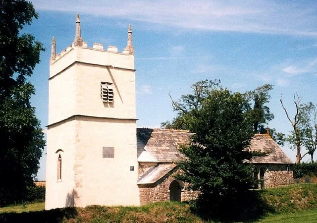
Boyton, Cornwall
Boyton (Cornish: Trevoya) is a civil parish and village in Cornwall, England, United Kingdom. It is situated close to the River Tamar and the border with Devon about six miles (10 km) north of Launces

John Baker — CC BY-SA 2.0 via Wikimedia Commons licence
Plan your visit
- Typical visit
- 30 min–1 h
- Free entry
About
Boyton (Cornish: Trevoya) is a civil parish and village in Cornwall, England, United Kingdom. It is situated close to the River Tamar and the border with Devon about six miles (10 km) north of Launceston. According to the 2001 census it had a population of 378.This increased to 457 at the 2011 census. Boyton is a rural parish which takes its name from Boia's Farm and is mentioned in the Domesday Book as Boitone. It is bounded to the east by the Devon border, to the north by North Tamerton parishes, to the west by North Petherwin parish, and to the south by Werrington parish. Boyton is in the Launceston Registration District. The manor of Boyton was recorded in the Domesday Book (1086) when it was one of several manors held by Hamelin from Robert, Count of Mortain. There was half a hide of land and land for 4 ploughs. There were 2 ploughs, 3 serfs, 2 villeins, 3 smallholders, 5 acres of woodland, 60 acres of pasture, 6 cattle and 30 sheep. The value of the manor was 15 shillings though it had formerly been worth £1 sterling. At Boyton Mill the miller's house is built of stone and wooden beams. The mill building itself has many original features, the waterwheel and machinery still turn and can be seen working. Some parts of the mill building dates back to the 13th century, and the main house dates back over 500 years. The hamlets of Bennacott, Curry Lane, North Beer and West Curry are in the parish.
Photo gallery
From the Wikipedia article
Boyton (Cornish: Trevoya) is a civil parish and village in Cornwall, England, United Kingdom. It is situated close to the River Tamar and the border with Devon about six miles (10 km) north of Launceston. According to the 2001 census it had a population of 378.This increased to 457 at the 2011 census. Boyton is a rural parish which takes its name from Boia's Farm and is mentioned in the Domesday Book as Boitone. It is bounded to the east by the Devon border, to the north by North Tamerton parishes, to the west by North Petherwin parish, and to the south by Werrington parish. Boyton is in the Launceston Registration District. The manor of Boyton was recorded in the Domesday Book (1086) when it was one of several manors held by Hamelin from Robert, Count of Mortain. There was half a hide of land and land for 4 ploughs. There were 2 ploughs, 3 serfs, 2 villeins, 3 smallholders, 5 acres of woodland, 60 acres of pasture, 6 cattle and 30 sheep. The value of the manor was 15 shillings though it had formerly been worth £1 sterling. At Boyton Mill the miller's house is built of stone and wooden beams. The mill building itself has many original features, the waterwheel and machinery still turn and can be seen working. Some parts of the mill building dates back to the 13th century, and the main house dates back over 500 years. The hamlets of Bennacott, Curry Lane, North Beer and West Curry are in the parish.
Excerpt from Wikipedia under CC BY-SA 4.0. See the source article linked in Sources below.
- Coordinates
- 50.7030, -4.3810
- District
- Cornwall
- Parish
- Boyton
- Postcode
- PL15 9RF
- Parliamentary constituency
- North Cornwall
Sources
- wikipedia: Boyton, Cornwall (CC BY-SA 4.0)
Other places nearby
Loading nearby places…
Nearby
 📷 3
📷 3Historic bridges · South West England
Haunch Bridge
Haunch Bridge — Grade II listed building-listed bridge in england-south-west, United Kingdom.
Vineyards · South West England
Northcott Wood camp
Northcott Wood camp — a UK vineyard in england south west, producing English or Welsh wine from cool-climate grape varieties.
 📷 3
📷 3Towns & cities · South West England
Luffincott
Luffincott — village in Devon, UK.
 📷 3
📷 3Historic bridges · South West England
Incline Plane, Bridge And Wheel Pit To East Of Plane Cottage
Incline Plane, Bridge And Wheel Pit To East Of Plane Cottage — Grade II listed building-listed bridge in england-south-west, United Kingdom.
 📷 3
📷 3Historic churches · South West England
St James's Church, Luffincott
St James's Church, Luffincott — church in Luffincott, Devon, England, UK.
 📷 5
📷 5Chapels · South West England
Bridgetown Methodist Chapel, Hall, Garage And Wall To Front
Bridgetown Methodist Chapel, Hall, Garage And Wall To Front — chapel in Werrington, Cornwall, England, UK.
More places in this region
 📷 5
📷 5Historic churches · South West England
Abbey Church of St Mary and St Petroc
Abbey Church of St Mary and St Petroc — church in Bodmin, Cornwall, England, UK; former monastic church.
 📷 5
📷 5Historic churches · South West England
All Saints Church
All Saints Church — church in Dodington, West Somerset, England, UK.
 📷 5
📷 5Historic churches · South West England
All Saints Church, Otterhampton
All Saints Church, Otterhampton — church in Otterhampton, Somerset, England, UK.
 📷 5
📷 5Historic churches · South West England
All Saints Church, South Milton
All Saints Church, South Milton — church in South Milton, Devon, England, UK.
Frequently asked questions
- Where is Boyton, Cornwall?
- Boyton, Cornwall is in South-West England, United Kingdom (postcode PL15 9RF), in the parish of Boyton.
- Is Boyton, Cornwall free to visit?
- Yes, Boyton, Cornwall is free to enter.
- How do I get to Boyton, Cornwall?
- Drivers can navigate to postcode PL15 9RF. It sits within the North Cornwall parliamentary constituency.