Towns & cities · South East England
Bottlesford
Bottlesford — village in Wiltshire, England, UK.

Wikimedia Commons contributors — see linked file page for photographer and licence licence
Plan your visit
- Typical visit
- 3 h–6 h
- Nearest railway station
- Pewsey · 5.0 km
- Free entry
- Family-friendly
- Dog-friendly
About
Bottlesford is a town, city, village or settlement in the United Kingdom. Wikidata describes it as: "village in Wiltshire, England, UK". Coordinates: 51.3300°, -1.8400°.
Photo gallery
Protected designations
- Site of Special Scientific Interest: River Avon System SSSI
- Area of Outstanding Natural Beauty: Cotswolds
- Area of Outstanding Natural Beauty: North Wessex Downs
Designations sourced from Natural England open data under OGL v3.
From the Wikipedia article
Bottlesford is a small village in Wiltshire, England, in the parish of North Newnton. It is in the Vale of Pewsey and is about 3 miles (4.8 km) west of Pewsey. There is a pub, the Seven Stars Inn. The Berks and Hants Extension Railway, opened from Hungerford to Devizes in 1862, passes north of Bottlesford. Sometime after 1958 the boundary of Woodborough parish was moved south to follow the railway, transferring the north end of Bottlesford into Woodborough. The properties immediately north of the railway are labelled as Free Trade on a 1958 map, but that name is not used today. Until sometime after 1971, Bottlesford was within Manningford parish, in the tithing of Manningford Bohune which had been part of Wilsford parish until 1871.
Excerpt from Wikipedia under CC BY-SA 4.0. See the source article linked in Sources below.
- Coordinates
- 51.3300, -1.8400
- District
- Wiltshire
- Parish
- North Newnton
- Postcode
- SN9 6LT
- Parliamentary constituency
- East Wiltshire
- Nearest railway station
- Pewsey — 5 km
Sources
- wikidata: Q958556 (CC0)
- wikipedia: Bottlesford (CC BY-SA 4.0)
- commons: The Seven Stars, Bottlesford - geograph.org.uk - 1427563.jpg (CC BY-SA 4.0)
Other places nearby
Loading nearby places…
Nearby
 📷 5
📷 5Towns & cities · South East England
Woodborough
Woodborough — village and civil parish in the Vale of Pewsey, Wiltshire, England.
 📷 5
📷 5Historic bridges · South East England
Woodborough Fields Bridge At Su 113607
Woodborough Fields Bridge At Su 113607 — Grade II listed building-listed bridge in england-south-east, United Kingdom.
B&Bs · South East England
Puckshipton House
Puckshipton House — a bed-and-breakfast in england south east.
 📷 5
📷 5Historic houses · South East England
God's Waiting Room
God's Waiting Room — a historic house in england-south-east, United Kingdom.
 📷 5
📷 5Archaeological sites · South East England
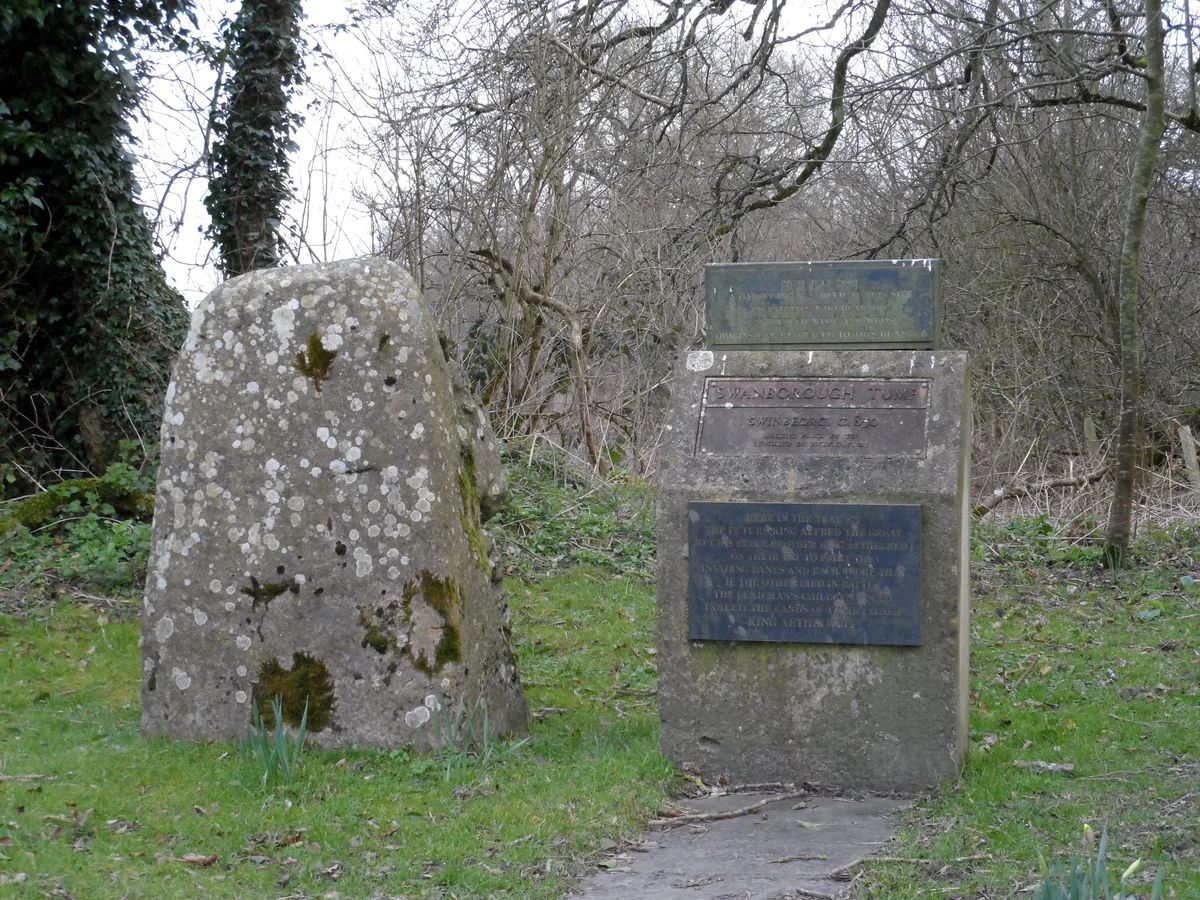
Swanborough Tump
Swanborough Tump — Bronze Age mound in Wiltshire, England, UK.
 Flagship📷 5
Stately homes · South East England
Wilsford Manor
Wilsford Manor — manor house in Wilsford, Wiltshire, England, UK.
More towns in this region
 Flagship📷 10
Towns & cities · South East England
Aldermaston
Aldermaston — village and civil parish in West Berkshire in England, UK.
 Flagship📷 10
Towns & cities · South East England
Aldingbourne
Aldingbourne — village and civil parish in Arun, West Sussex, UK.
 Flagship📷 10
Towns & cities · South East England
Aldington
Aldington — village and civil parish in the Ashford District of Kent, England.
 Flagship📷 10
Towns & cities · South East England
Aldworth
Aldworth — village and civil parish in the English county of Berkshire.
Frequently asked questions
- Where is Bottlesford?
- Bottlesford is in South-East England, United Kingdom (postcode SN9 6LT), in the parish of North Newnton.
- Is Bottlesford a protected site?
- Yes — Bottlesford is part of the River Avon System SSSI Site of Special Scientific Interest and the Cotswolds National Landscape (AONB).
- Is Bottlesford free to visit?
- Yes, Bottlesford is free to enter.
- How do I get to Bottlesford?
- The nearest railway station is Pewsey, about 5.0 km away. Drivers can navigate to postcode SN9 6LT.