Natural landmarks · North East England
Bleaberry Tarn
Bleaberry Tarn — lake in the United Kingdom.

Wikimedia Commons contributors — see linked file page for photographer and licence licence
Plan your visit
- Typical visit
- 1 h–2 h
- Free entry
- Dog-friendly
About
Bleaberry Tarn is a named natural landmark in the United Kingdom. Wikidata describes it as: "lake in the United Kingdom". Coordinates: 54.5272°, -3.2903°.
Photo gallery
Protected designations
- Site of Special Scientific Interest: River Derwent and Tributaries SSSI
- Site of Special Scientific Interest: Buttermere Fells SSSI
- National Nature Reserve: WILD ENNERDALE
Designations sourced from Natural England open data under OGL v3.
From the Wikipedia article
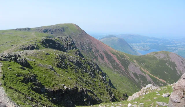
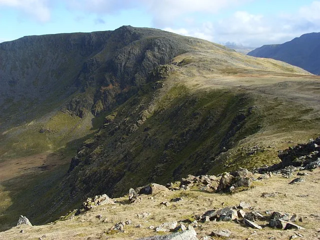
Bleaberry Tarn is a small natural mountain tarn near Buttermere in the English Lake District. Located at NY165154 (OS Landranger 89), it lies in a corrie below the Lakeland fells of Red Pike and High Stile, backed by Chapel Crags on the ridge between them. The footpath ascending Red Pike from Buttermere skirts its north side. A. Wainwright describes the tarn as "secluded" and suggests it formed in a volcanic crater. The stream Sour Milk Gill descends from the tarn to Buttermere, and is followed by one of the popular footpaths ascending Red Pike. In the 19th century, it was sometimes additionally known as "Burtness Tarn" or "Blebba Tarn".
Excerpt from Wikipedia under CC BY-SA 4.0. See the source article linked in Sources below.
- Coordinates
- 54.5272, -3.2903
- District
- Cumberland
- Parish
- Buttermere
- Postcode
- CA13 9UZ
- Parliamentary constituency
- Penrith and Solway
Sources
- wikidata: Q883285 (CC0)
- wikipedia: Bleaberry Tarn (CC BY-SA 4.0)
- commons: Bleaberry Tarn - geograph.org.uk - 290127.jpg (CC BY-SA 4.0)
Other places nearby
Loading nearby places…
Nearby
 📷 3
📷 3Mountains & hills · North East England
Red Pike
Red Pike — Named summit at 755.3 m.
 📷 3
📷 3Natural landmarks · North East England
Red Pike
Red Pike — fell near Buttermere in the Lake District, England.
 📷 3
📷 3Mountains & hills · North East England
High Stile (Wainwright)
High Stile (Wainwright) — Named summit at 806.2 m.
 📷 3
📷 3Natural landmarks · North East England
High Stile
High Stile — mountain in Lake District, UK.
Climbing & bouldering crags · North East England
Grey Crag
Grey Crag — a climbing crag in england north east.
Climbing & bouldering crags · North East England
Comb Crag
Comb Crag — a climbing crag in england north east.
More natural landmarks in this region
 Flagship📷 5
Natural landmarks · North East England
Brothers Water
Brothers Water — lake in Cumbria, England, UK.
 📷 5
📷 5Natural landmarks · North East England
Angle Tarn
Angle Tarn — lake near Patterdale, Cumbria, England, United Kingdom.
 📷 3
📷 3Natural landmarks · North East England
Angletarn Pikes
Angletarn Pikes — mountain in United Kingdom.
 📷 3
📷 3Natural landmarks · North East England
Ard Crags
Ard Crags — mountain in United Kingdom.
Frequently asked questions
- Where is Bleaberry Tarn?
- Bleaberry Tarn is in North-East England, United Kingdom (postcode CA13 9UZ), in the parish of Buttermere.
- Is Bleaberry Tarn a protected site?
- Yes — Bleaberry Tarn is part of the River Derwent and Tributaries SSSI Site of Special Scientific Interest and the Buttermere Fells SSSI Site of Special Scientific Interest.
- Is Bleaberry Tarn free to visit?
- Yes, Bleaberry Tarn is free to enter.
- How do I get to Bleaberry Tarn?
- Drivers can navigate to postcode CA13 9UZ. It sits within the Penrith and Solway parliamentary constituency.