Mountains & hills · North West England
Black Fell
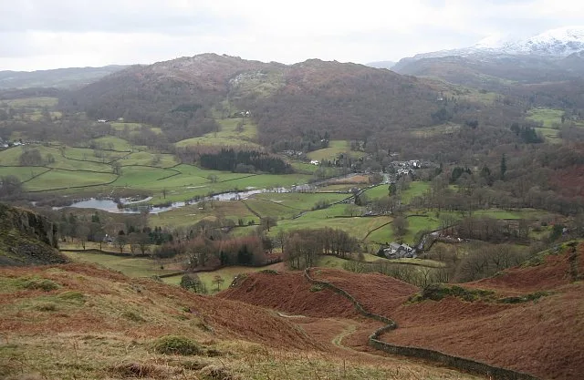
Black Fell — Named summit at 323 m.

Wikimedia Commons contributors — see linked file page for photographer and licence licence
Plan your visit
- Typical visit
- 3 h–8 h
- Best time of year
- Late spring – early autumn (May–Oct)
- Nearest railway station
- Windermere · 8.0 km
- Free entry
- Dog-friendly
About
Black Fell is a named summit in the United Kingdom. Wikidata describes it as: "Named summit at 323 m.". Coordinates: 54.4055°, -3.0179°.
Photo gallery
Protected designations
- Site of Special Scientific Interest: River Eden and Tributaries SSSI
Designations sourced from Natural England open data under OGL v3.
From the Wikipedia article
Black Fell is a fell in the English Lake District. It rises to the north of Tarn Hows, between Coniston and Hawkshead.
Excerpt from Wikipedia under CC BY-SA 4.0. See the source article linked in Sources below.
- Coordinates
- 54.4055, -3.0179
- District
- Westmorland and Furness
- Parish
- Skelwith
- Postcode
- LA21 8DW
- Parliamentary constituency
- Westmorland and Lonsdale
- Nearest railway station
- Windermere — 8 km
Sources
- osm: n29876661 (ODbL)
- wikipedia: Black Fell (Lake District) (CC BY-SA 4.0)
- commons: Black Fell.jpg (CC BY-SA 4.0)
Other places nearby
Loading nearby places…
Nearby
 📷 3
📷 3Natural landmarks · North West England
Black Fell
Black Fell — mountain in United Kingdom.
 📷 3
📷 3Viewpoints · North West England
View point looking north west
View point looking north west is a viewpoint in the United Kingdom.
 📷 3
📷 3Historic bridges · North West England
Skelwith Bridge (That Part Within Lakes District)
Skelwith Bridge (That Part Within Lakes District) — Grade II listed building-listed bridge in england-north-west, United Kingdom.
Caravan parks · North West England
Skelwith Fold Caravan Park
Skelwith Fold Caravan Park — a caravan park in england north west.
 📷 3
📷 3Viewpoints · North West England
Tarn Hows Viewpoint
Tarn Hows Viewpoint is a viewpoint in the United Kingdom.
 📷 3
📷 3Natural landmarks · North West England
Yew Tree Tarn
Yew Tree Tarn — lake in Cumbria, United Kingdom.
More mountains in this region
 📷 3
📷 3Mountains & hills · North West England
Allen Crags
Allen Crags — Named summit at 785 m.
 📷 3
📷 3Mountains & hills · North West England
Alum Pot
Alum Pot — Open shaft pothole in North Yorkshire.
 📷 3
📷 3Mountains & hills · North West England
Arnside Knott
Arnside Knott — Named summit at 159 m.
 📷 3
📷 3Mountains & hills · North West England
Aye Gill Pike
Aye Gill Pike — Named summit at 556.3 m.
Frequently asked questions
- Where is Black Fell?
- Black Fell is in North-West England, United Kingdom (postcode LA21 8DW), in the parish of Skelwith.
- Is Black Fell a protected site?
- Yes — Black Fell is part of the River Eden and Tributaries SSSI Site of Special Scientific Interest.
- Is Black Fell free to visit?
- Yes, Black Fell is free to enter.
- How do I get to Black Fell?
- Drivers can navigate to postcode LA21 8DW. It sits within the Westmorland and Lonsdale parliamentary constituency.