Natural landmarks · North West England
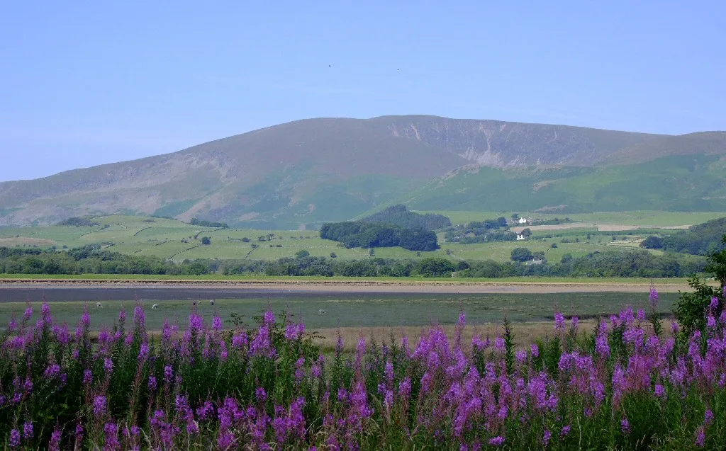
Black Combe
Black Combe — mountain in United Kingdom.

Wikimedia Commons contributors — see linked file page for photographer and licence licence
Plan your visit
- Typical visit
- 1 h–2 h
- Nearest railway station
- Silecroft · 3.4 km
- Free entry
- Dog-friendly
About
Black Combe is a named natural landmark in the United Kingdom. Wikidata describes it as: "mountain in United Kingdom". Coordinates: 54.2569°, -3.3293°.
Photo gallery
Protected designations
- Site of Special Scientific Interest: Duddon Estuary SSSI
- Ramsar wetland: Duddon Estuary
Designations sourced from Natural England open data under OGL v3.
From the Wikipedia article
Black Combe is a fell in the south-west corner of the Lake District National Park, England, just 4 miles (6.4 km) from the Irish Sea. It lies near the west coast of Cumbria in the district of Cumberland and more specifically, in the ancient district of Millom. It is 1,970 ft (600 m) high and stands in isolation, some 10 mi (16 km) away from any higher ground; this factor offers an excellent all-round panoramic view of land and sea, weather permitting. Black Combe is a Marilyn and, at 600m, it is only 10m short of being a Hewitt. Sub-tops include White Combe, Stoupdale Head, Swinside Fell and Stoneside Hill. The first two but not the last two are included in the index of Wainwright's The Outlying Fells of Lakeland and thus in lists of "Outlying fells". (All four sub-tops are shown on Wainwright's map of the fell in that book The view from Black Combe is unique, a result of its isolated position to the south and west of the main Lake District fells. William Wordsworth claimed that "the amplest range of unobstructed prospect may be seen that British ground commands". Half the view is the glittering sea, with the Isle of Man seen clearly to the west, and the hills of Wales and Scotland seen as shadowy silhouettes. On the seaward side views extend from the Cumbrian coast, and from Criffel, 49 mi (79 km) to the north, a mountain on the Scottish coast near Dumfries, round to the Isle of Man, 45 mi (72 km) due west, then round to Snowdon which may be seen on days of exceptionally good visibility, 85 mi (137 km) to the south, to the coast of Lancashire. On the landward side, views include the Scafell Group and the Coniston Group of fells in the Lake District National Park, including four 3,000 ft (910 m) mountains: Skiddaw, Scafell, Scafell Pike and Helvellyn. To the east and south the Pennine Hills, the Forest of Bowland and Blackpool Tower are visible. Closer by, there are also good views over the Duddon Estuary, Millom and the wind farm just offshore. Black Combe is easy…
Excerpt from Wikipedia under CC BY-SA 4.0. See the source article linked in Sources below.
- Coordinates
- 54.2569, -3.3293
- District
- Cumberland
- Parish
- Whicham
- Postcode
- LA18 5LU
- Parliamentary constituency
- Barrow and Furness
- Nearest railway station
- Silecroft — 3.4 km
Sources
- wikidata: Q4920562 (CC0)
- wikipedia: Black Combe (CC BY-SA 4.0)
- commons: Black combe from foxfield.JPG (CC BY-SA 4.0)
Other places nearby
Loading nearby places…
Nearby
 📷 3
📷 3Mountains & hills · North West England
Black Combe
Black Combe — Named summit at 600 m.
 📷 3
📷 3Viewpoints · North West England
Seaness
Seaness is a viewpoint in the United Kingdom.
 📷 3
📷 3Historic churches · North West England
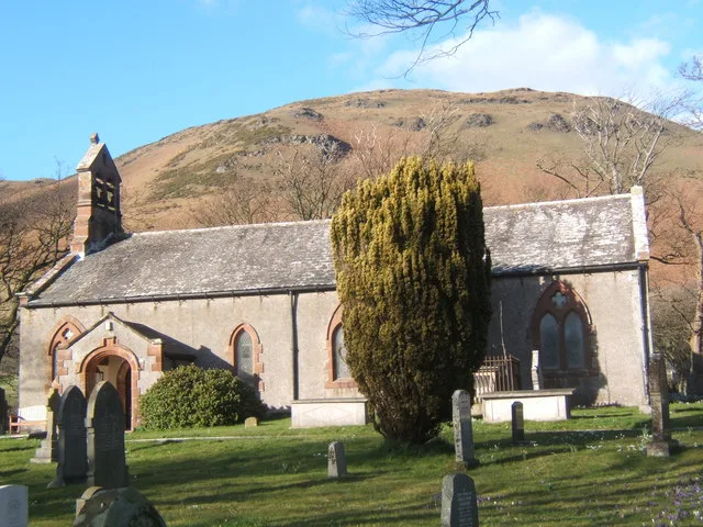
St Mary's Church, Whicham
St Mary's Church, Whicham — grade II listed church in Whicham, Cumberland, Cumbria, England, UK.
 📷 3
📷 3Memorials & monuments · North West England
Whicham and Silecroft War Memorial
Whicham and Silecroft War Memorial — Grade II listed building-listed memorial in england-north-west, United Kingdom.
Campsites · North West England
Baystone Bank Farm Camping Site
Baystone Bank Farm Camping Site — a campsite in england north west.
 📷 3
📷 3Reservoirs & lochs · North West England
Baystone Bank Reservoir
Baystone Bank Reservoir — reservoir in Cumbria, England, UK.
More natural landmarks in this region
 ★ Iconic📷 4
Natural landmarks · North West England
Coniston Water
Lake District lake — Swallows and Amazons setting and Donald Campbell water-speed history.
 📷 3
📷 3Natural landmarks · North West England
Elter Water
Elter Water — lake in the United Kingdom.
 📷 3
📷 3Natural landmarks · North West England
Esthwaite Water
Esthwaite Water — lake in the United Kingdom.
 Flagship📷 5
Natural landmarks · North West England
Semerwater
Semerwater — lake in North Yorkshire, England, UK.
Frequently asked questions
- Where is Black Combe?
- Black Combe is in North-West England, United Kingdom (postcode LA18 5LU), in the parish of Whicham.
- Is Black Combe a protected site?
- Yes — Black Combe is part of the Duddon Estuary SSSI Site of Special Scientific Interest and the Duddon Estuary Ramsar wetland.
- Is Black Combe free to visit?
- Yes, Black Combe is free to enter.
- How do I get to Black Combe?
- The nearest railway station is Silecroft, about 3.4 km away. Drivers can navigate to postcode LA18 5LU.