Natural landmarks · North West England
Birks Fell
Birks Fell — mountain in United Kingdom.

Wikimedia Commons contributors — see linked file page for photographer and licence licence
Plan your visit
- Typical visit
- 1 h–2 h
- Free entry
- Dog-friendly
About
Birks Fell is a named natural landmark in the United Kingdom. Wikidata describes it as: "mountain in United Kingdom". Coordinates: 54.1830°, -2.1259°.
Photo gallery
Protected designations
- Site of Special Scientific Interest: Upper Wharfedale SSSI
Designations sourced from Natural England open data under OGL v3.
From the Wikipedia article
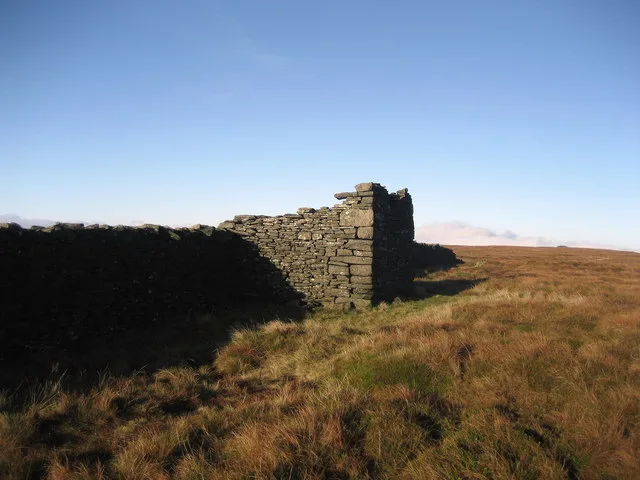
Birks Fell is a hill in the Yorkshire Dales, near to Hubberholme in North Yorkshire, England. It is classed as a Marilyn (a hill with topographic prominence of at least 150m). Birks Fell only became an official Marilyn in 2006 as it was resurveyed and discovered to be 610 metres (2,001 ft) and not 608 metres (1,995 ft) as previously thought. Books from the late 19th and early 20th centuries list the hill as being 2,001 feet (610 m) and it is thought that in the conversion to metric, the hill lost some height. This raises it above neighbouring Horse Head Moor (609 m), making it the Marilyn in place of Horse Head Moor. Between the summit and a trig point (1 mile (1.6 km) to the south west) lies Birks Tarn, which is one or the largest tarns in the Yorkshire Dales. It is prevented from leaking through the bedrock underneath by its impermeable layers and additionally held back by the peaty soil. The section at the top of the fell is a wide ridge that offers excellent walking and "outstanding views". The eastern slope of the fell was mined for lead between 1699 and 1815. Ruined buildings that were formerly used in the metal winning process still dot the landscape. The name Birks derives from the Old Norse word for birch; the lower slopes of the hill used to be covered in them.
Excerpt from Wikipedia under CC BY-SA 4.0. See the source article linked in Sources below.
- Coordinates
- 54.1830, -2.1259
- District
- North Yorkshire
- Parish
- Buckden
- Postcode
- BD23 5JD
- Parliamentary constituency
- Skipton and Ripon
Sources
- wikidata: Q4916509 (CC0)
- wikipedia: Birks Fell (CC BY-SA 4.0)
- commons: Ruin on Birks Fell - geograph.org.uk - 296211.jpg (CC BY-SA 4.0)
Other places nearby
Loading nearby places…
Nearby
 📷 3
📷 3Mountains & hills · North West England
Birks Fell
Birks Fell — Named summit at 610 m.
 📷 3
📷 3Archaeological sites · North West England
sink holes or mining activitiy
sink holes or mining activitiy — a archaeological in england-north-west, United Kingdom.
 📷 3
📷 3Archaeological sites · North West England
mining spoil heaps?
mining spoil heaps? — a archaeological in england-north-west, United Kingdom.
 📷 3
📷 3Caves · North West England
Birks Fell Cave
Birks Fell Cave is a cave in the United Kingdom.
 📷 3
📷 3Caves · North West England
Redmire Pot
Redmire Pot is a cave in the United Kingdom.
📷 3Caves · North West England
Birk Bank Cave
Birk Bank Cave is a cave in the United Kingdom.
More natural landmarks in this region
 ★ Iconic📷 4
Natural landmarks · North West England
Coniston Water
Lake District lake — Swallows and Amazons setting and Donald Campbell water-speed history.
 📷 3
📷 3Natural landmarks · North West England
Elter Water
Elter Water — lake in the United Kingdom.
 📷 3
📷 3Natural landmarks · North West England
Esthwaite Water
Esthwaite Water — lake in the United Kingdom.
 Flagship📷 5
Natural landmarks · North West England
Semerwater
Semerwater — lake in North Yorkshire, England, UK.
Frequently asked questions
- Where is Birks Fell?
- Birks Fell is in North-West England, United Kingdom (postcode BD23 5JD), in the parish of Buckden.
- Is Birks Fell a protected site?
- Yes — Birks Fell is part of the Upper Wharfedale SSSI Site of Special Scientific Interest.
- Is Birks Fell free to visit?
- Yes, Birks Fell is free to enter.
- How do I get to Birks Fell?
- Drivers can navigate to postcode BD23 5JD. It sits within the Skipton and Ripon parliamentary constituency.