Natural landmarks · Scottish Highlands
Beinn Dubhchraig
Also known as: Beinn Dubh-chreig
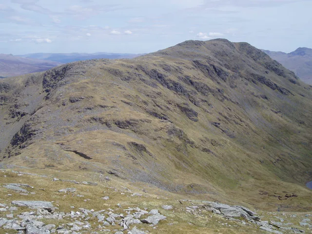
Beinn Dubhchraig — 978m high mountain in Stirling, Scotland, UK.

Wikimedia Commons contributors — see linked file page for photographer and licence licence
Plan your visit
- Typical visit
- 1 h–2 h
- Nearest railway station
- Tyndrum Lower · 5.0 km
- Free entry
- Dog-friendly
About
Beinn Dubhchraig is a named natural landmark in the United Kingdom. Wikidata describes it as: "978m high mountain in Stirling, Scotland, UK". Coordinates: 56.3913°, -4.7432°.
Photo gallery
From the Wikipedia article
Beinn Dubhchraig (Scottish Gaelic: Beinn Dubhchreig) is a mountain in the Scottish Highlands, west of Crianlarich in the northern part of Loch Lomond and the Trossachs National Park. It is a Munro with a height of 978 metres (3,209 ft). It is overshadowed by its neighbour Ben Lui, although it is well seen from the main A82 road. Its name means "mountain of the black rock", referring to the steep and rocky face on the southwest slopes above Loch Oss, which offer scrambling routes to the summit.
Excerpt from Wikipedia under CC BY-SA 4.0. See the source article linked in Sources below.
- Coordinates
- 56.3913, -4.7432
- Address
- Stirlingshire, Scotland
- Nearest railway station
- Tyndrum Lower — 5 km
- Official site
- www.walkhighlands.co.uk
Sources
- wikidata: Q3397916 (CC0)
- wikipedia: Beinn Dubhchraig (CC BY-SA 4.0)
- commons: Bealach between Ben Oss and Ben Dubhchraig - geograph.org.uk - 122147.jpg (CC BY-SA 4.0)
Other places nearby
Loading nearby places…
Nearby
 📷 3
📷 3Mountains & hills · Scottish Highlands
Beinn Dubhchraig
Beinn Dubhchraig — Named summit at 978 m.
 📷 3
📷 3National parks · Scottish Highlands
Tyndrum Hills
Tyndrum Hills in Scotland Islands, United Kingdom.
📷 3Mountains & hills · Scottish Highlands
Ben Oss North Top
Ben Oss North Top — a mountain in scotland-highlands, United Kingdom.
 📷 3
📷 3Mountains & hills · Scottish Highlands
Ben Oss
Ben Oss — Named summit at 1029 m.
 📷 3
📷 3Natural landmarks · Scottish Highlands
Ben Oss
Ben Oss — 1029m high mountain in Stirling, Scotland, UK.
 📷 3
📷 3Mountains & hills · Scottish Highlands
Fiarach
Fiarach — a mountain in scotland-highlands, United Kingdom, 652 m.
More natural landmarks in this region
 Flagship📷 3
Natural landmarks · Scottish Highlands
Dunalastair Water
Dunalastair Water — lake in Perth and Kinross, Scotland, UK, on the River Tummel.
 Flagship📷 3
Natural landmarks · Scottish Highlands
Loch Arkaig
Loch Arkaig — lake in Highland, Scotland, UK, outflows east to River Arkaig.
 Flagship📷 3
Natural landmarks · Scottish Highlands
Loch Assynt
Loch Assynt — lake in Highland, Scotland, UK, outflows to the River Inver and Loch na Garbh Uidhe.
 Flagship📷 3
Natural landmarks · Scottish Highlands
Loch Awe
Loch Awe — lake in Argyll and Bute, Scotland, UK, outflows to the River Awe.
Frequently asked questions
- Where is Beinn Dubhchraig?
- Beinn Dubhchraig is in the Scottish Highlands, United Kingdom.
- Is Beinn Dubhchraig free to visit?
- Yes, Beinn Dubhchraig is free to enter.
- How do I get to Beinn Dubhchraig?
- The nearest railway station is Tyndrum Lower, about 5.0 km away.