Natural landmarks · Scottish Highlands
Beinn a' Bhùird
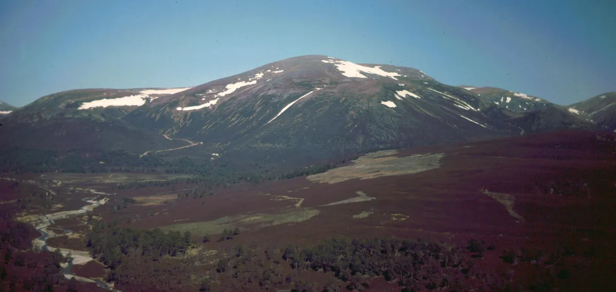
Beinn a' Bhùird — Munro in the Cairngorm mountain range of Scotland.

Wikimedia Commons contributors — see linked file page for photographer and licence licence
Plan your visit
- Typical visit
- 1 h–2 h
- Nearest railway station
- Ptarmigan Station · 9.7 km
- Free entry
- Dog-friendly
About
Beinn a' Bhùird is a named natural landmark in the United Kingdom. Wikidata describes it as: "Munro in the Cairngorm mountain range of Scotland". Coordinates: 57.0876°, -3.4994°.
Photo gallery
From the Wikipedia article
Beinn a' Bhùird is a Munro in the Cairngorm mountain range of Scotland. In Watson (1975) the author suggests the mountain should be named Beinn Bòrd – table hill, saying that local Scottish Gaelic speakers pronounced the mountain Paing Bòrd, with some of the older local folk still using Painna Bòrd. The closest 'village' to Beinn a' Bhùird is Braemar, Aberdeenshire and the most common approach by car is through this village. To reach Beinn a' Bhùird by car, the most common approach is by the Linn of Dee road along the south side of the River Dee to the Linn of Dee, looping back along the north bank to the car park at Allanaquoich where camping is permitted. By this route, the distance between Braemar and Allanaquoich is about 10 miles (16 kilometres). In 2006, a glider pilot from Deeside Gliding Club crashed on the hillside, spending 24 hours trapped in his plane until he was located by the RAF.
Excerpt from Wikipedia under CC BY-SA 4.0. See the source article linked in Sources below.
- Coordinates
- 57.0876, -3.4994
- Address
- Moray / Aberdeenshire
- Nearest railway station
- Ptarmigan Station — 9.7 km
- Official site
- www.walkhighlands.co.uk
Sources
- wikidata: Q3355661 (CC0)
- wikipedia: Beinn a' Bhùird (CC BY-SA 4.0)
- commons: Beinn-a-bhuird-01.jpg (CC BY-SA 4.0)
Other places nearby
Loading nearby places…
Nearby
 📷 3
📷 3Mountains & hills · Scottish Highlands
Beinn a' Bhùird North Top
Beinn a' Bhùird North Top — Named summit at 1196 m.
 📷 3
📷 3Mountains & hills · Scottish Highlands
Cnap a' Chleirich
Cnap a' Chleirich — a mountain in scotland-highlands, United Kingdom.
 📷 3
📷 3Mountains & hills · Scottish Highlands
Beinn a' Bhuird South Top
Beinn a' Bhuird South Top — a mountain in scotland-highlands, United Kingdom.
📷 3Mountains & hills · Scottish Highlands
A' Chìoch
A' Chìoch — a mountain in scotland-highlands, United Kingdom.
 📷 3
📷 3Memorials & monuments · Scottish Highlands
RAF aircrew killed flying in the Cairngorms Memorial
RAF aircrew killed flying in the Cairngorms Memorial — a memorial in scotland-highlands, United Kingdom.
📷 3Mountains & hills · Scottish Highlands
Stob an t-Sluichd
Stob an t-Sluichd — a mountain in scotland-highlands, United Kingdom.
More natural landmarks in this region
 Flagship📷 3
Natural landmarks · Scottish Highlands
Dunalastair Water
Dunalastair Water — lake in Perth and Kinross, Scotland, UK, on the River Tummel.
 Flagship📷 3
Natural landmarks · Scottish Highlands
Loch Arkaig
Loch Arkaig — lake in Highland, Scotland, UK, outflows east to River Arkaig.
 Flagship📷 3
Natural landmarks · Scottish Highlands
Loch Assynt
Loch Assynt — lake in Highland, Scotland, UK, outflows to the River Inver and Loch na Garbh Uidhe.
 Flagship📷 3
Natural landmarks · Scottish Highlands
Loch Awe
Loch Awe — lake in Argyll and Bute, Scotland, UK, outflows to the River Awe.
Frequently asked questions
- Where is Beinn a' Bhùird?
- Beinn a' Bhùird is in Scottish Highlands, in the United Kingdom — coordinates 57.0876°, -3.4994°. The nearest railway station is Ptarmigan Station, around 9.7 km away.
- Is Beinn a' Bhùird free to visit?
- Yes — admission to Beinn a' Bhùird is free.