Forests & woodlands · London
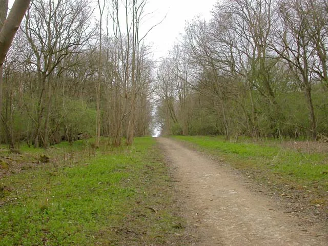
Bedford Purlieus National Nature Reserve
Bedford Purlieus National Nature Reserve is a forest or woodland in the United Kingdom.

Wikimedia Commons contributors — see linked file page for photographer and licence licence
Plan your visit
- Typical visit
- 1 h–3 h
- Nearest railway station
- Yarwell Junction (NVR) · 4.4 km
- Free entry
- Family-friendly
- Dog-friendly
- Limited wheelchair access
About
Bedford Purlieus National Nature Reserve is a named forest, woodland or nature reserve in the United Kingdom. Records date its origin to 2000. Coordinates: 52.5847°, -0.4622°.
Photo gallery
Protected designations
- Site of Special Scientific Interest: Bedford Purlieus SSSI
- National Nature Reserve: BEDFORD PURLIEUS
Designations sourced from Natural England open data under OGL v3.
From the Wikipedia article
Bedford Purlieus is a 211-hectare (520-acre) ancient woodland in Cambridgeshire, in the United Kingdom. It is a national nature reserve and Site of Special Scientific Interest owned and managed by the Forestry Commission. In Thornhaugh civil parish, 10 km (6.2 mi) south of Stamford and 14 km (8.7 mi) west of Peterborough, the wood is within the Peterborough unitary authority area of Cambridgeshire, and borders Northamptonshire. In Roman times it was an iron smelting centre, during the medieval period it was in the Royal Forest of Rockingham, and later it became part of the estates of the Duke of Bedford. Bedford Purlieus appears to have been continuously wooded at least from Roman times, and probably since the ice receded. The woodland may have the richest range of vascular plants of any English lowland wood. It acquired particular significance in the 1970s as an early subject for the historical approach to ecology and woodland management.
Excerpt from Wikipedia under CC BY-SA 4.0. See the source article linked in Sources below.
Background
Description
For 400 years the woods were part of the Wansford Estate, itself a part of the vast land holdings of the Russell family, Earls, and later Dukes of Bedford. It is this connection that is responsible for the name, and under their management, profound changes have taken place to both the size and character of the woods.
Sourced from Wikipedia under CC BY-SA 4.0.
- Coordinates
- 52.5847, -0.4622
- District
- Peterborough
- Parish
- Thornhaugh
- Postcode
- PE8 6NN
- Parliamentary constituency
- North West Cambridgeshire
- Established
- 2000
- Nearest railway station
- Yarwell Junction (NVR) — 4.4 km
Sources
- osm: w331966869 (ODbL)
- wikipedia: Bedford Purlieus National Nature Reserve (CC BY-SA 4.0)
- commons: Bedford Purlieus - geograph.org.uk - 1228194.jpg (CC BY-SA 4.0)
Other places nearby
Loading nearby places…
Nearby
 📷 5
📷 5Historic houses · London
Wartime buildings
Wartime buildings — a historic house in england-london, United Kingdom.
 📷 5
📷 5Wildlife reserves · London
Old Sulehay Forest
Old Sulehay Forest — nature reserve in the United Kingdom.
 📷 5
📷 5Memorials & monuments · London
Glen Miller Pillar
Glen Miller Pillar is a memorial in the United Kingdom.
 📷 5
📷 5Memorials & monuments · London
Kings Cliffe Airfield Memorial
Kings Cliffe Airfield Memorial — a memorial in england-london, United Kingdom.
.jpg?width=1200) 📷 5
📷 5Historic houses · London
Manor House
Manor House — historic building in Thornhaugh, City of Peterborough, England, United Kingdom.
 📷 5
📷 5Wildlife reserves · London
Wansford Pasture
Wansford Pasture — nature reserve in the United Kingdom.
Other forests from this era
 📷 5
📷 5Forests & woodlands · London
Angel's Wings
Angel's Wings — Public artwork by Thomas Heatherwick.
 📷 5
📷 5Forests & woodlands · London
RSPB Fowlmere Nature Reserve
RSPB Fowlmere Nature Reserve is a forest or woodland in the United Kingdom.
 📷 5
📷 5Forests & woodlands · London
RSPB The Lodge nature reserve
RSPB The Lodge nature reserve is a forest or woodland in the United Kingdom.
 📷 5
📷 5Forests & woodlands · London
The London Wetland Centre
The London Wetland Centre is a forest or woodland in the United Kingdom.
More forests in this region
 📷 5
📷 5Forests & woodlands · London
Ackroyd Drive Green Link
Ackroyd Drive Green Link is a forest or woodland in the United Kingdom.
 📷 5
📷 5Forests & woodlands · London
Adams Road Bird Sanctuary
Adams Road Bird Sanctuary is a forest or woodland in the United Kingdom.
 📷 5
📷 5Forests & woodlands · London
Adelaide Nature Reserve
Adelaide Nature Reserve is a forest or woodland in the United Kingdom.
 📷 5
📷 5Forests & woodlands · London
Arthur Jacob Nature Reserve
Arthur Jacob Nature Reserve is a forest or woodland in the United Kingdom.
Frequently asked questions
- Where is Bedford Purlieus National Nature Reserve?
- Bedford Purlieus National Nature Reserve is in London, United Kingdom (postcode PE8 6NN), in the parish of Thornhaugh.
- When was Bedford Purlieus National Nature Reserve built?
- Built or established in 2000.
- Is Bedford Purlieus National Nature Reserve a protected site?
- Yes — Bedford Purlieus National Nature Reserve is part of the Bedford Purlieus SSSI Site of Special Scientific Interest and the BEDFORD PURLIEUS National Nature Reserve.
- Is Bedford Purlieus National Nature Reserve free to visit?
- Yes, Bedford Purlieus National Nature Reserve is free to enter.
- How do I get to Bedford Purlieus National Nature Reserve?
- The nearest railway station is Yarwell Junction (NVR), about 4.4 km away. Drivers can navigate to postcode PE8 6NN.