Museums · Yorkshire & the Humber
Bedale
Bedale ( BEE-dayl), is a market town and civil parish in North Yorkshire, England. Bedale Beck is a tributary of the River Swale, which forms one of the Yorkshire Dales. The dale has a predominant agr

Bill Harrison — CC BY-SA 2.0 via Wikimedia Commons licence
Plan your visit
- Typical visit
- 1.5 h–3 h
- Best time of year
- Year-round
- Family-friendly
- Limited wheelchair access
About
Bedale ( BEE-dayl), is a market town and civil parish in North Yorkshire, England. Bedale Beck is a tributary of the River Swale, which forms one of the Yorkshire Dales. The dale has a predominant agriculture sector and its related small traditional trades, although tourism is increasingly important. Northallerton is 7 miles (11 km) north-east, Middlesbrough 26 miles (42 km) north-east and York is 31 miles (50 km) south-south-east. Historically part of the North Riding of Yorkshire, the town was listed in Domesday Book under what became the honour of Richmond. The honour had several wapentakes and Bedale was part of Hang (named after Hang Bank in Finghall or alternatively named after Catterick) and later Hang East.
Photo gallery
From the Wikipedia article
Bedale ( BEE-dayl), is a market town and civil parish in North Yorkshire, England. Bedale Beck is a tributary of the River Swale, which forms one of the Yorkshire Dales. The dale has a predominant agriculture sector and its related small traditional trades, although tourism is increasingly important. Northallerton is 7 miles (11 km) north-east, Middlesbrough 26 miles (42 km) north-east and York is 31 miles (50 km) south-south-east. Historically part of the North Riding of Yorkshire, the town was listed in Domesday Book under what became the honour of Richmond. The honour had several wapentakes and Bedale was part of Hang (named after Hang Bank in Finghall or alternatively named after Catterick) and later Hang East.
Excerpt from Wikipedia under CC BY-SA 4.0. See the source article linked in Sources below.
Background
History
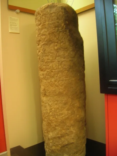
]] Before the Harrying of the North Bedale was held by Torpin (Thorfinn), a patronym retained by the infamous Dick Turpin. The parish church also dates from this time (as evidenced by its crypt), before significant remodelling. The original 9th-century church escaped destruction in the Harrying of the North and was recorded in Domesday Book. The recent discovery of the Bedale Hoard provides further evidence of high-status Anglo-Saxon and Viking Age activity in the area. The town was recorded as Bedell or Bedhal and derives from 'Beda's Halh', which means the corner or piece of land of Beda.
Sourced from Wikipedia under CC BY-SA 4.0.
- Coordinates
- 54.2881, -1.5914
- District
- North Yorkshire
- Parish
- Bedale
- Postcode
- DL8 2BJ
- Parliamentary constituency
- Thirsk and Malton
- Official site
- www.bigsheeplittlecow.co.uk
Sources
- wikipedia: Bedale (CC BY-SA 4.0)
Other places nearby
Loading nearby places…
Nearby
 📷 5
📷 5Gardens · Yorkshire & the Humber
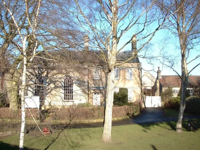
Bedale Leech House
Bedale Leech House — a garden in england-yorkshire, United Kingdom.
 📷 3
📷 3Natural landmarks · Yorkshire & the Humber
Bedale Station
Bedale Station — a other in england-yorkshire, United Kingdom.
 📷 5
📷 5Historic houses · Yorkshire & the Humber
Bedale Hall
Bedale Hall — house in Bedale, North Yorkshire, England, UK.
 📷 3
📷 3Memorials & monuments · Yorkshire & the Humber
War Memorial to South of St Gregory's Church
War Memorial to South of St Gregory's Church — Grade II listed building-listed memorial in england-yorkshire, United Kingdom.
 📷 3
📷 3Farms (open to visitors) · Yorkshire & the Humber
Big Sheep and Little Cow Farm
Big Sheep and Little Cow Farm — a other in england-yorkshire, United Kingdom.
.jpg?width=1200) 📷 3
📷 3Mills · Yorkshire & the Humber
Aiskew Mill
Aiskew Mill — mill in Aiskew and Leeming Bar, Hambleton, England, UK.
More museums in this region
 📷 3
📷 3Museums · Yorkshire & the Humber
Aldborough Roman Town
Aldborough Roman Town — Heritage Museum in Yorkshire, England, UK.
 📷 3
📷 3Museums · Yorkshire & the Humber
Bayle Museum
Bayle Museum — Local museum in Bridlington, England.
Museums · Yorkshire & the Humber
BD1 Gallery
BD1 Gallery — closed gallery in Bradford, West Yorkshire.
 📷 5
📷 5Museums · Yorkshire & the Humber
Beck Isle Museum
Beck Isle Museum — museum in Pickering, North Yorkshire, England, United Kingdom.
Frequently asked questions
- Where is Bedale?
- Bedale is in Yorkshire & the Humber, in the United Kingdom — coordinates 54.2881°, -1.5914°.
- Is Bedale wheelchair accessible?
- Partially — OpenStreetMap notes limited wheelchair access at Bedale. Check ahead for specific facilities.