Hill forts · Northern Ireland
Beaghmore
Also known as: An Bheitheach Mhór
Beaghmore — complex of early Bronze Age megalithic features in Northern Ireland.

Wikimedia Commons contributors — see linked file page for photographer and licence licence
Plan your visit
- Typical visit
- 1 h–2 h
- Free entry
- Dog-friendly
About
Beaghmore is a hill fort in the United Kingdom. Wikidata describes it as: "complex of early Bronze Age megalithic features in Northern Ireland". Coordinates: 54.7015°, -6.9387°.
Photo gallery
From the Wikipedia article
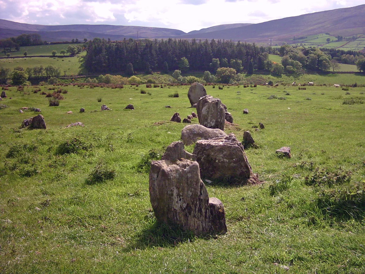
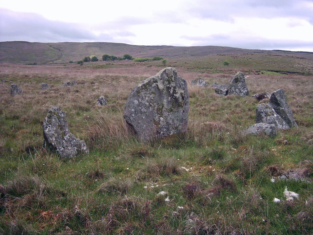
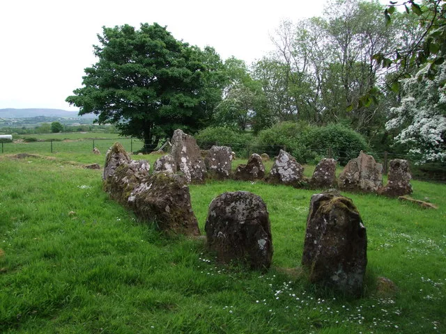
Beaghmore is a complex of early Bronze Age megalithic features, stone circles and cairns, 8.5 miles north west of Cookstown, County Tyrone in Northern Ireland, on the south-east edge of the Sperrin Mountains. Mackay's Dictionary of Ulster Place-names says that it is from Irish an Bheitheach Mhór, meaning "big place of birch trees", a name that reflects the fact that the area was a woodland before being cleared by Neolithic farmers. Beaghmore stone circles, alignments and cairns are State Care Historic Monuments in the townland of Beaghmore, in the Cookstown District Council area, grid ref: Area of H684 842. At Beaghmore a cairn (grid ref: H6872 8470), a cairn (grid ref: H6856 8472), stone circles, alignments and cairns (grid ref: area of H684 842), round cairn with standing stones: Bradley's Cairn (grid ref: H6830 8401) and cairn and alignment (grid ref: H6863 8431), are all Scheduled Historic Monuments.
Excerpt from Wikipedia under CC BY-SA 4.0. See the source article linked in Sources below.
Background
Description
at Beaghmore.]] at Beaghmore.]] There are seven low stone circles of different sizes, six of which are paired, twelve cairns and ten stone rows. The circles are between 10 and 20m in diameter, and are associated with earlier burial cairns and alignments of stone rows lead towards them. The stones are small with few more than 0.5m in height and the circles are distorted, suggesting they are related to kerbs surrounding some megalithic tombs. A typical feature of the stone rows is a high and low arrangement where short rows of tall stones run beside much longer rows of small stones.
Sourced from Wikipedia under CC BY-SA 4.0.
- Coordinates
- 54.7015, -6.9387
- District
- Mid Ulster
- Postcode
- BT80 9PA
- Parliamentary constituency
- Mid Ulster
Sources
- wikidata: Q812903 (CC0)
- wikipedia: Beaghmore (CC BY-SA 4.0)
- commons: Co.Tyrone, Beaghmore.jpg (CC BY-SA 4.0)
Other places nearby
Loading nearby places…
Nearby
 📷 3
📷 3Stone circles · Northern Ireland
Beaghmore Stone Circle D
Beaghmore Stone Circle D — a stone circle in northern-ireland, United Kingdom.
📷 3Stone circles · Northern Ireland
Beaghmore Stone Circle C
Beaghmore Stone Circle C — a stone circle in northern-ireland, United Kingdom.
 📷 3
📷 3Stone circles · Northern Ireland
Beaghmore Stone Circle E
Beaghmore Stone Circle E — a stone circle in northern-ireland, United Kingdom.
📷 3Stone circles · Northern Ireland
Beaghmore Stone Circle B
Beaghmore Stone Circle B — a stone circle in northern-ireland, United Kingdom.
📷 3Stone circles · Northern Ireland
Beaghmore Stone Circle A
Beaghmore Stone Circle A — a stone circle in northern-ireland, United Kingdom.
 📷 3
📷 3Stone circles · Northern Ireland
Beaghmore Stone Circle G
Beaghmore Stone Circle G — a stone circle in northern-ireland, United Kingdom.
More places in this region
 📷 3
📷 3Hill forts · Northern Ireland
Aughlish
Aughlish — archaeological site in County Londonderry, Northern Ireland, England, UK.
 📷 3
📷 3Hill forts · Northern Ireland
Corick
Corick — archaeological site in United Kingdom.
 📷 3
📷 3Hill forts · Northern Ireland
Craig Hill
Craig Hill is a hill fort in the United Kingdom.
 📷 2
📷 2Hill forts · Northern Ireland
Dooey's Cairn
Dooey's Cairn — archaeological site in County Antrim, Northern Ireland.
Frequently asked questions
- Where is Beaghmore?
- Beaghmore is in Northern Ireland, United Kingdom (postcode BT80 9PA).
- Is Beaghmore free to visit?
- Yes, Beaghmore is free to enter.
- How do I get to Beaghmore?
- Drivers can navigate to postcode BT80 9PA. It sits within the Mid Ulster parliamentary constituency.