Towns & cities · London
Barkway
Barkway — village and civil parish in the North Hertfordshire district of Hertfordshire, England.

Wikimedia Commons contributors — see linked file page for photographer and licence licence
Plan your visit
- Typical visit
- 3 h–6 h
- Nearest railway station
- Royston · 6.6 km
- Free entry
- Family-friendly
- Dog-friendly
About
Barkway is a town, city, village or settlement in the United Kingdom. Recent population estimates put it at around 656 people. Address: SG8. Wikidata describes it as: "village and civil parish in the North Hertfordshire district of Hertfordshire, England". Coordinates: 52.0000°, 0.0150°.
Photo gallery
From the Wikipedia article
Barkway is a village and civil parish in the North Hertfordshire district of Hertfordshire, England, about five miles south-east of Royston, 35 miles from London and 15 miles from the centre of Cambridge. The Greenwich Prime Meridian passes a mile or so to the west of Barkway.
Excerpt from Wikipedia under CC BY-SA 4.0. See the source article linked in Sources below.
Background
History
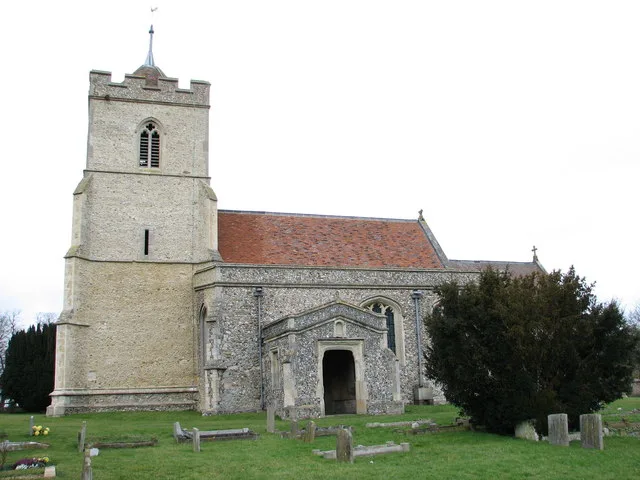
Barkway is reputedly listed in the Domesday Book of 1086 as Birchwig, meaning Birch Way. Barkway has a number of 15th and 16th century properties, some with thatched roofs. Most properties are on or near the High Street, which is part of the old London to Cambridge coaching route. Barkway has had a village church for over 1,000 years. The current flint and stone church, which is over 800 years old and dedicated to St Mary Magdalene, has a full peal of 8 bells which are rung every week.
Sourced from Wikipedia under CC BY-SA 4.0.
- Coordinates
- 52.0000, 0.0150
- County
- Hertfordshire
- District
- North Hertfordshire
- Parish
- Barkway
- Postcode
- SG8
- Parliamentary constituency
- North East Hertfordshire
- Population
- 656
- Nearest railway station
- Royston — 6.6 km
- Official site
- www.barkway-village.org.uk
Sources
- wikidata: Q785229 (CC0)
- wikipedia: Barkway (CC BY-SA 4.0)
- commons: Barkway village sign and pond - geograph.org.uk - 1380716.jpg (CC BY-SA 4.0)
Other places nearby
Loading nearby places…
Nearby
 📷 5
📷 5Forts · London
Obelisk About 350 Metres South South West Of Newsells Park House (Not Listed)
Obelisk About 350 Metres South South West Of Newsells Park House (Not Listed) — a martello broad in england-london, United Kingdom.
 📷 5
📷 5Towns & cities · London
Reed
Reed — village and civil parish in Hertfordshire, UK.
 📷 3
📷 3Gardens · London
Newsells Park
Newsells Park — a garden in england-london, United Kingdom.
 📷 5
📷 5Historic churches · London
St Andrew's Church, Buckland
St Andrew's Church, Buckland — church in East Hertfordshire, England, UK.
 📷 5
📷 5Castles · London
Anstey Castle
Anstey Castle was in the village of Anstey, Hertfordshire. It was a 12th-century stone motte and bailey fortress that, according to tradition, was founded by Eustace II, Count of Boulogne. It was eith
 📷 5
📷 5Historic churches · London
Church of St George
Church of St George — church in Anstey, Hertfordshire, England, UK.
More towns in this region
 Flagship📷 10
Towns & cities · London
Aldenham
Aldenham — village and civil parish in Hertfordshire, England.
 Flagship📷 10
Towns & cities · London
Ashdon
Ashdon — village and civil parish in Essex, UK.
 Flagship📷 10
Towns & cities · London
Betchworth
Betchworth — village and civil parish in the Mole Valley district of Surrey, England.
 Flagship📷 10
Towns & cities · London
Boxley
Boxley — village and civil parish in Maidstone District, Kent, England, UK.
Frequently asked questions
- Where is Barkway?
- Barkway is in Hertfordshire, London, United Kingdom (postcode SG8), in the parish of Barkway.
- Is Barkway free to visit?
- Yes, Barkway is free to enter.
- How do I get to Barkway?
- The nearest railway station is Royston, about 6.6 km away. Drivers can navigate to postcode SG8.