Natural landmarks · Scottish Highlands
Baosbheinn
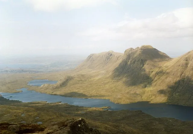
Baosbheinn — mountain in Highland, Scotland, UK.

Wikimedia Commons contributors — see linked file page for photographer and licence licence
Plan your visit
- Typical visit
- 1 h–2 h
- Free entry
- Dog-friendly
About
Baosbheinn is a named natural landmark in the United Kingdom. Part of Northwest Highlands. Wikidata describes it as: "mountain in Highland, Scotland, UK". Coordinates: 57.6278°, -5.5665°.
Photo gallery
From the Wikipedia article
Baosbheinn is a Scottish mountain situated in the Torridon area of the Northwest Highlands. It stands in a remote area within the Flowerdale deer forest some 39 km NNE of Kyle of Lochalsh.
Excerpt from Wikipedia under CC BY-SA 4.0. See the source article linked in Sources below.
Background
Description
Baosbheinn, which is made up of Torridon Sandstone reaches a height of 875 m making it the 56th highest Corbett and the 277th highest Marilyn. It is a long elongated mountain with a NW-SE orientation. It has an impressive summit ridge, which barely drops below the 700 m contour in its 3 km length. Its SW slopes drops away steeply and rockily towards Loch a’ Ghobhainn while its NE slopes are less precipitous, throwing out a series of spurs which produces three craggy corries. Strong hill walkers can climb Baosbheinn with the adjacent Corbett of Beinn an Eoin which stands across Loch na h-Oidhche and gives a demanding circular walk of 21 km which takes between six and nine hours.
Sourced from Wikipedia under CC BY-SA 4.0.
- Coordinates
- 57.6278, -5.5665
- Address
- Wester Ross, Scotland
Sources
- wikidata: Q4857474 (CC0)
- wikipedia: Baosbheinn (CC BY-SA 4.0)
- commons: Baosbheinn - geograph.org.uk - 516270.jpg (CC BY-SA 4.0)
Other places nearby
Loading nearby places…
Nearby
 📷 3
📷 3Mountains & hills · Scottish Highlands
Baosbheinn
Baosbheinn — Named summit at 875 m.
 📷 5
📷 5Mountains & hills · Scottish Highlands
Ceann Beag
Ceann Beag — a mountain in scotland-highlands, United Kingdom.

Mountains & hills · Scottish Highlands
Creag an Fhithich
Creag an Fhithich — a mountain in scotland-highlands, United Kingdom.
 📷 2
📷 2Forests & woodlands · Scottish Highlands
Loch na h-Oidhche
Loch na h-Oidhche in Scotland Islands, United Kingdom.
 📷 2
📷 2Reservoirs & lochs · Scottish Highlands
Loch a' Ghobhainn
Loch a' Ghobhainn in Scotland Islands, United Kingdom.
 📷 3
📷 3Mountains & hills · Scottish Highlands
Beinn an Eoin North Top
Beinn an Eoin North Top — a mountain in scotland-highlands, United Kingdom.
More natural landmarks in this region
 Flagship📷 3
Natural landmarks · Scottish Highlands
Dunalastair Water
Dunalastair Water — lake in Perth and Kinross, Scotland, UK, on the River Tummel.
 Flagship📷 3
Natural landmarks · Scottish Highlands
Loch Arkaig
Loch Arkaig — lake in Highland, Scotland, UK, outflows east to River Arkaig.
 Flagship📷 3
Natural landmarks · Scottish Highlands
Loch Assynt
Loch Assynt — lake in Highland, Scotland, UK, outflows to the River Inver and Loch na Garbh Uidhe.
 Flagship📷 3
Natural landmarks · Scottish Highlands
Loch Awe
Loch Awe — lake in Argyll and Bute, Scotland, UK, outflows to the River Awe.
Frequently asked questions
- Where is Baosbheinn?
- Baosbheinn is in Scottish Highlands, in the United Kingdom — coordinates 57.6278°, -5.5665°.
- Is Baosbheinn free to visit?
- Yes — admission to Baosbheinn is free.