Towns & cities · Northern Ireland
Ballyeaston
Ballyeaston — village in County Antrim, Northern Ireland, UK.

Wikimedia Commons contributors — see linked file page for photographer and licence licence
Plan your visit
- Typical visit
- 3 h–6 h
- Nearest railway station
- Mossley West · 8.4 km
- Free entry
- Family-friendly
- Dog-friendly
About
Ballyeaston is a town, city, village or settlement in the United Kingdom. Wikidata describes it as: "village in County Antrim, Northern Ireland, UK". Coordinates: 54.7667°, -6.0000°.
Photo gallery
From the Wikipedia article
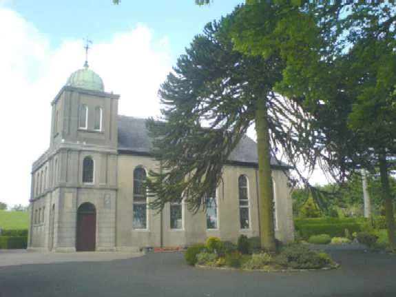
Ballyeaston, formerly spelt Ballyistin (from Irish Baile Uistín, meaning 'Uistín's townland'), is a small village and townland in County Antrim, Northern Ireland. It is 2–3 km north of Ballyclare, on the road to Larne. It lies on the southern hill slopes overlooking Six Mile Water. In the 2001 census it had a population of 90 people. It is within the Antrim & Newtownabbey Borough Council area. The village is centred on a junction of three main routes that meet near a medieval parish church. Its buildings cluster between the landmark churches, with the modern facade of First Ballyeaston Presbyterian Church and the bronze cupola of Second Ballyeaston Presbyterian Church. The Boy's Brigade Company belongs to 2nd Ballyeaston while the Girl's Brigade belongs to 1st Ballyeaston and boys and girls from both churches attend each. At the time of the 1859 Ulster revival, the minister of 2nd Ballyeaston was Rev A. Pollock. Reference books state that the revival hit the parish with such power, he died as a result of his strenuous labours. He is buried in the small graveyard behind the church and the inscription on his headstone says that he died in the field with his armour on. In the middle of the village is a group of buildings on both sides of the Trenchill Road, a steep and winding road, which forms the village's main street. At the top of the main street is the old Ballyeaston Flute Band Hall.
Excerpt from Wikipedia under CC BY-SA 4.0. See the source article linked in Sources below.
- Coordinates
- 54.7667, -6.0000
- District
- Antrim and Newtownabbey
- Postcode
- BT39 9WN
- Parliamentary constituency
- South Antrim
- Nearest railway station
- Mossley West — 8.4 km
Sources
- wikidata: Q1130072 (CC0)
- wikipedia: Ballyeaston (CC BY-SA 4.0)
- commons: 044 - 2nd Ballyeaston Church.jpg (CC BY-SA 4.0)
Other places nearby
Loading nearby places…
Nearby
 📷 3
📷 3Historic houses · Northern Ireland
St. Agustines Church of Ireland
St. Agustines Church of Ireland — a historic house in northern-ireland, United Kingdom.
 📷 3
📷 3Historic churches · Northern Ireland
Second Ballyeaston Presbyterian Church
Second Ballyeaston Presbyterian Church — church building in Ballyeaston, County Antrim, Northern Ireland.
 📷 3
📷 3Cemeteries · Northern Ireland
Rashee Graveyard
Rashee Graveyard is a cemetery in the United Kingdom.
 📷 4
📷 4Historic houses · Northern Ireland
Ballyclare Town Hall
Ballyclare Town Hall in Northern Ireland, United Kingdom.
 📷 3
📷 3Theatres · Northern Ireland
Reo Cinema
Reo Cinema in Northern Ireland, United Kingdom.
 📷 4
📷 4Natural landmarks · Northern Ireland
Ballyclare railway station
Ballyclare railway station in Northern Ireland, United Kingdom.
More towns in this region
 Flagship📷 5
Towns & cities · Northern Ireland
Bangor
Bangor — city in Northern Ireland, United Kingdom.
 Flagship📷 5
Towns & cities · Northern Ireland
Belfast
Belfast — capital city of Northern Ireland.
 Flagship📷 3
Towns & cities · Northern Ireland
Derry
Derry — city in Northern Ireland.
 Flagship📷 5
Towns & cities · Northern Ireland
Lisburn
Lisburn — city in Northern Ireland.
Frequently asked questions
- Where is Ballyeaston?
- Ballyeaston is in Northern Ireland, United Kingdom (postcode BT39 9WN).
- Is Ballyeaston free to visit?
- Yes, Ballyeaston is free to enter.
- How do I get to Ballyeaston?
- Drivers can navigate to postcode BT39 9WN. It sits within the South Antrim parliamentary constituency.