Museums · Yorkshire & the Humber
Baildon
Baildon is a town and civil parish in the Bradford Metropolitan Borough in West Yorkshire, England and within the historic boundaries of the West Riding of Yorkshire. It lies 3 miles (5 km) north of B

Roger Templeman — CC BY-SA 2.0 via Wikimedia Commons licence
Plan your visit
- Typical visit
- 1.5 h–3 h
- Best time of year
- Year-round
- Family-friendly
- Limited wheelchair access
About
Baildon is a town and civil parish in the Bradford Metropolitan Borough in West Yorkshire, England and within the historic boundaries of the West Riding of Yorkshire. It lies 3 miles (5 km) north of Bradford city centre. The town forms a continuous urban area with Shipley and Bradford, and is part of the West Yorkshire Built-up Area. Other nearby suburbs include Shipley to the south and Saltaire to the west. As of the 2011 census, the Baildon ward had a population of 15,360.
Photo gallery
From the Wikipedia article
Baildon is a town and civil parish in the Bradford Metropolitan Borough in West Yorkshire, England and within the historic boundaries of the West Riding of Yorkshire. It lies 3 miles (5 km) north of Bradford city centre. The town forms a continuous urban area with Shipley and Bradford, and is part of the West Yorkshire Built-up Area. Other nearby suburbs include Shipley to the south and Saltaire to the west. As of the 2011 census, the Baildon ward had a population of 15,360.
Excerpt from Wikipedia under CC BY-SA 4.0. See the source article linked in Sources below.
Background
History
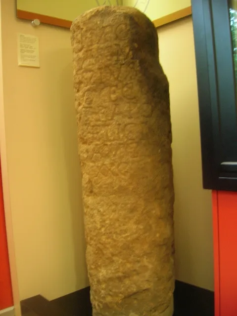
Cup-and-ring stones on Baildon Moor have shown evidence of Bronze Age inhabitation. Baildon Moor has a number of gritstone outcrops with numerous prehistoric cup and ring marks. A denuded and mutilated bank represents the remains of an Iron Age settlement known as Soldier's Trench, sometimes mistaken for a Bronze Age stone circle. A Bronze Age cup-marked rock is incorporated in the bank. The name Baildon derives from the Old English bēgeldūn meaning 'bend hill' or 'circle hill'. Baildon is recorded as Beldone and Beldune in the Domesday Book. In 1066 it belonged to a Gospatric, son of Arnketil, and had passed to Erneis of Buron by 1086. Baildon had two manor houses: one on Hall Cliffe, the…
Sourced from Wikipedia under CC BY-SA 4.0.
- Coordinates
- 53.8510, -1.7630
- District
- Bradford
- Parish
- Baildon
- Postcode
- BD17 6NP
- Parliamentary constituency
- Shipley
Sources
- wikipedia: Baildon (CC BY-SA 4.0)
Other places nearby
Loading nearby places…
Nearby
 📷 3
📷 3Memorials & monuments · Yorkshire & the Humber
Frances Ferrand Memorial Fountain
Frances Ferrand Memorial Fountain — a memorial in england-yorkshire, United Kingdom.
 📷 3
📷 3Theatres · Yorkshire & the Humber
Cinema
Cinema in England Yorkshire, United Kingdom.
Climbing & bouldering crags · Yorkshire & the Humber
Baildon Bank
Baildon Bank — a climbing crag in england yorkshire.
 📷 3
📷 3Archaeological sites · Yorkshire & the Humber
Cup and Ring Stone
Cup and Ring Stone — a archaeological in england-yorkshire, United Kingdom.
 📷 3
📷 3Forests & woodlands · Yorkshire & the Humber
Denso Marston Nature Reserve
Denso Marston Nature Reserve is a forest or woodland in the United Kingdom.
 📷 3
📷 3Memorials & monuments · Yorkshire & the Humber
Tong Park Memorial
Tong Park Memorial — a memorial in england-yorkshire, United Kingdom.
More museums in this region
 📷 3
📷 3Museums · Yorkshire & the Humber
Aldborough Roman Town
Aldborough Roman Town — Heritage Museum in Yorkshire, England, UK.
 📷 3
📷 3Museums · Yorkshire & the Humber
Bayle Museum
Bayle Museum — Local museum in Bridlington, England.
Museums · Yorkshire & the Humber
BD1 Gallery
BD1 Gallery — closed gallery in Bradford, West Yorkshire.
 📷 5
📷 5Museums · Yorkshire & the Humber
Beck Isle Museum
Beck Isle Museum — museum in Pickering, North Yorkshire, England, United Kingdom.
Frequently asked questions
- Where is Baildon?
- Baildon is in Yorkshire & the Humber, in the United Kingdom — coordinates 53.8510°, -1.7630°.
- Is Baildon wheelchair accessible?
- Partially — OpenStreetMap notes limited wheelchair access at Baildon. Check ahead for specific facilities.