Castles · South West England
Babcary
Babcary is a village and civil parish in Somerset, England, about 5 miles (8.0 km) east of Somerton and 6 miles (9.7 km) southwest of Castle Cary. The village has a population of 248. It lies close to

Milestone Society — CC BY-SA 2.0 via Wikimedia Commons licence
Plan your visit
- Typical visit
- 1.5 h–3 h
- Family-friendly
- Limited wheelchair access
About
Babcary is a village and civil parish in Somerset, England, about 5 miles (8.0 km) east of Somerton and 6 miles (9.7 km) southwest of Castle Cary. The village has a population of 248. It lies close to the River Cary and the A37. The parish includes the hamlet of Foddington.
Photo gallery
From the Wikipedia article
Babcary is a village and civil parish in Somerset, England, about 5 miles (8.0 km) east of Somerton and 6 miles (9.7 km) southwest of Castle Cary. The village has a population of 248. It lies close to the River Cary and the A37. The parish includes the hamlet of Foddington.
Excerpt from Wikipedia under CC BY-SA 4.0. See the source article linked in Sources below.
Background
History
The village was recorded in the Domesday Book of 1086 as Babba Cari. The parish was part of the hundred of Catsash. Within the parish is Wimble Toot, generally interpreted as a Bronze Age bowl barrow, but an alternative interpretation is that it was a motte built between 1067 and 1069. Today the site forms a circular earthwork, 27.47 m across and 2.74 m high, with a ditch on the north-west and south-east sides, on the top of a ridge, overlooking a brook which runs into the River Cary and the old Roman road of the Fosse Way. The Red Lion Inn has 17th-century origins and is a Grade II listed building. The parish council was concerned with the insanitary drainage system for the village, but…
Sourced from Wikipedia under CC BY-SA 4.0.
- Coordinates
- 51.0541, -2.6220
- District
- Somerset
- Parish
- Babcary
- Postcode
- TA11 7ED
- Parliamentary constituency
- Glastonbury and Somerton
Sources
- wikipedia: Babcary (CC BY-SA 4.0)
Other places nearby
Loading nearby places…
Nearby
 📷 5
📷 5Castles · South West England
Wimble Toot
Wimble Toot — a castle in england-south-west, United Kingdom.
 📷 3
📷 3Castles · South West England
Wimble Toot Castle
Wimble Toot Castle — a castle in england-south-west, United Kingdom.
Vineyards · South West England
Medieval settlement 190m south west of Perry's Bridge
Medieval settlement 190m south west of Perry's Bridge — a UK vineyard in england south west, producing English or Welsh wine from cool-climate grape varieties.
Caravan parks · South West England
The Cross Keys Inn Caravan and Motorhome Park
The Cross Keys Inn Caravan and Motorhome Park — a caravan park in england south west.
 📷 3
📷 3Historic bridges · South West England
Road Bridge At Ngr St 5468 2694
Road Bridge At Ngr St 5468 2694 — Grade II listed building-listed bridge in england-south-west, United Kingdom.
Vineyards · South West England
Medieval settlement remains 100m and 250m north of Downhead Manor Farm
Medieval settlement remains 100m and 250m north of Downhead Manor Farm — a UK vineyard in england south west, producing English or Welsh wine from cool-climate grape varieties.
More castles in this region
 📷 5
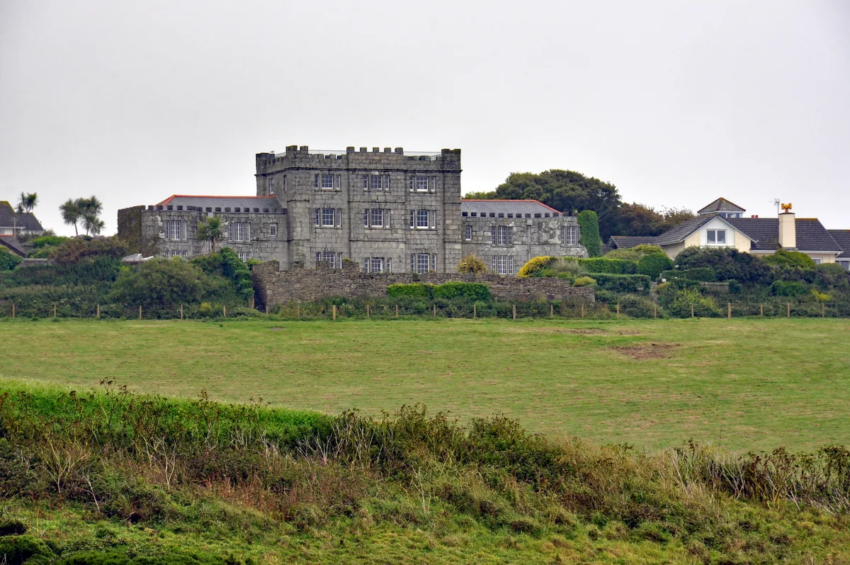
📷 5Castles · South West England
Acton Castle
Acton Castle — Cornish historic building.
 📷 5
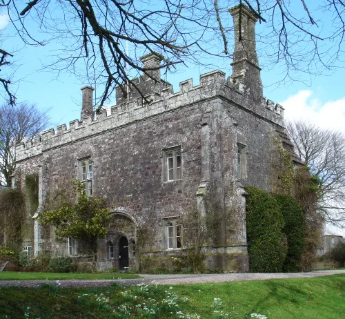
📷 5Castles · South West England
Affeton Castle
Affeton Castle — castle in East Worlington, Devon, England, UK.
 📷 5
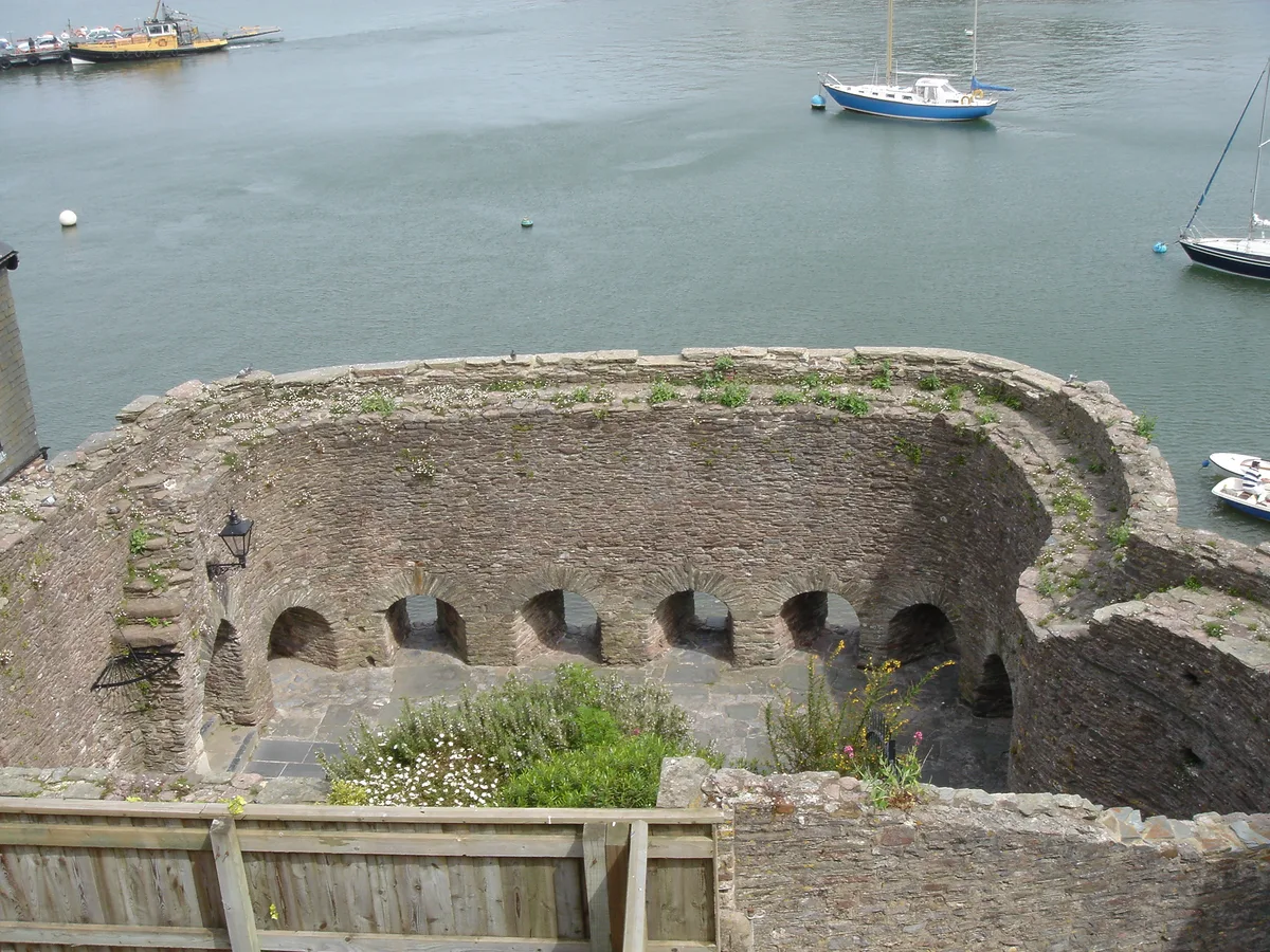
📷 5Castles · South West England
Bayard's Cove Fort
Bayard's Cove Fort — castle in Devon, England, UK.
 📷 5
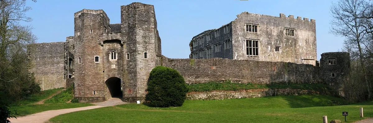
📷 5Castles · South West England
Berry Pomeroy Castle
Berry Pomeroy Castle — Grade I listed English country house in South Hams, United Kingdom.
Frequently asked questions
- Where is Babcary?
- Babcary is in South-West England, United Kingdom (postcode TA11 7ED), in the parish of Babcary.
- Does Babcary charge admission?
- Babcary typically charges admission. Check the official site for current ticket prices and opening hours.
- How do I get to Babcary?
- Drivers can navigate to postcode TA11 7ED. It sits within the Glastonbury and Somerton parliamentary constituency.