Towns & cities · Central Scotland
Auchtertool
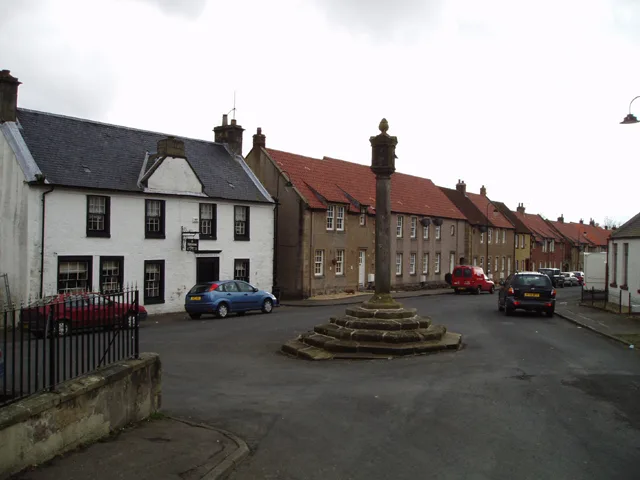
Auchtertool — village in Fife, Scotland, UK.

Wikimedia Commons contributors — see linked file page for photographer and licence licence
Plan your visit
- Typical visit
- 3 h–6 h
- Nearest railway station
- Cardenden · 4.6 km
- Free entry
- Family-friendly
- Dog-friendly
About
Auchtertool is a town, city, village or settlement in the United Kingdom. Recent population estimates put it at around 635 people. Wikidata describes it as: "village in Fife, Scotland, UK". Coordinates: 56.1000°, -3.2500°.
Photo gallery
From the Wikipedia article
Auchtertool ( ; Scottish Gaelic: Uachdar Tuil) is a small village in Fife, Scotland. It is 4 miles west of Kirkcaldy. The name is from the Gaelic uachdar, meaning upland or heights above the Tiel burn (from Gaelic tuil meaning torrent). The Tiel Burn flows a few hundred yards south of the kirk and village, which was formerly known as Milton of Auchtertool.
Excerpt from Wikipedia under CC BY-SA 4.0. See the source article linked in Sources below.
Background
History
David I gave the lands of Auchtertool to Bishop Gregory of Dunkeld between 1132 and 1153, meaning it formed, alongside neighbouring Aberdour, a detached portion of that diocese which was otherwise entirely surrounded by the diocese of St Andrews. However, the greater lands of the parish remained with the bishops of Dunkeld, who maintained an episcopal residence in the parish at Hallyards Castle. Hallyards Castle formerly stood north-west of the main village. Supposed originally to have been a hunting seat of Malcolm Canmore, it was the residence of the Bishops of Dunkeld until 1539. King James V visited the castle after his defeat at the Battle of Solway Moss in late November 1542.…
Sourced from Wikipedia under CC BY-SA 4.0.
- Coordinates
- 56.1000, -3.2500
- District
- Fife
- Postcode
- KY2 5XJ
- Parliamentary constituency
- Cowdenbeath and Kirkcaldy
- Population
- 635
- Nearest railway station
- Cardenden — 4.6 km
Sources
- wikidata: Q758625 (CC0)
- wikipedia: Auchtertool (CC BY-SA 4.0)
- commons: Auchtertool - geograph.org.uk - 141832.jpg (CC BY-SA 4.0)
Other places nearby
Loading nearby places…
Nearby
 📷 3
📷 3Historic houses · Central Scotland
Mourn House
Mourn House — a historic house in scotland-central, United Kingdom.
 📷 5
📷 5Castles · Central Scotland
Balmuto Castle
Balmuto Castle — a castle in scotland-central, United Kingdom.
 📷 5
📷 5Historic bridges · Central Scotland
Balmuto Bridge
Balmuto Bridge — category C listed building-listed bridge in scotland-central, United Kingdom.
📷 5Historic bridges · Central Scotland
Lambert's Mill Bridge
Lambert's Mill Bridge — category C listed building-listed bridge in scotland-central, United Kingdom.
📷 3Historic houses · Central Scotland
Damhead
Damhead — a historic house in scotland-central, United Kingdom.
 📷 5
📷 5Reservoirs & lochs · Scottish Highlands
Raith, Fife
Raith, Fife in Scotland Islands, United Kingdom.
More towns in this region
 Flagship📷 3
Towns & cities · Central Scotland
Airth
Airth — village in Falkirk, Scotland, UK.
 Flagship📷 5
Towns & cities · Central Scotland
Avonbridge
Avonbridge — village in Falkirk, Scotland, UK.
 Flagship📷 3
Towns & cities · Central Scotland
Banknock
Banknock — village in Falkirk, Scotland, UK.
 Flagship📷 3
Towns & cities · Central Scotland
Dundee
Dundee — city in Scotland, UK.
Frequently asked questions
- Where is Auchtertool?
- Auchtertool is in central Scotland, United Kingdom (postcode KY2 5XJ).
- Is Auchtertool free to visit?
- Yes, Auchtertool is free to enter.
- How do I get to Auchtertool?
- The nearest railway station is Cardenden, about 4.6 km away. Drivers can navigate to postcode KY2 5XJ.