Towns & cities · West Midlands
Astwood
Also known as: Astwood, Swydd Buckingham
Astwood — village and civil parish in Buckinghamshire, UK.

Wikimedia Commons contributors — see linked file page for photographer and licence licence
Plan your visit
- Typical visit
- 3 h–6 h
- Nearest railway station
- Kempston Hardwick · 7.8 km
- Free entry
- Family-friendly
- Dog-friendly
About
Astwood is a town, city, village or settlement in the United Kingdom. Recent population estimates put it at around 204 people. Address: MK16. Wikidata describes it as: "village and civil parish in Buckinghamshire, UK". Coordinates: 52.1161°, -0.6105°.
Photo gallery
From the Wikipedia article
Astwood is a village and civil parish in the unitary authority area of the City of Milton Keynes, Buckinghamshire, England. It is located on the border with Bedfordshire, approximately 6 miles (9.7 km) east of Newport Pagnell, 7 miles (11 km) west of Bedford and 8 miles (13 km) north-east of Central Milton Keynes. In 2021 the parish had a population of 217. The village name is Anglo-Saxon in origin and means "east wood".
Excerpt from Wikipedia under CC BY-SA 4.0. See the source article linked in Sources below.
Background
Architecture
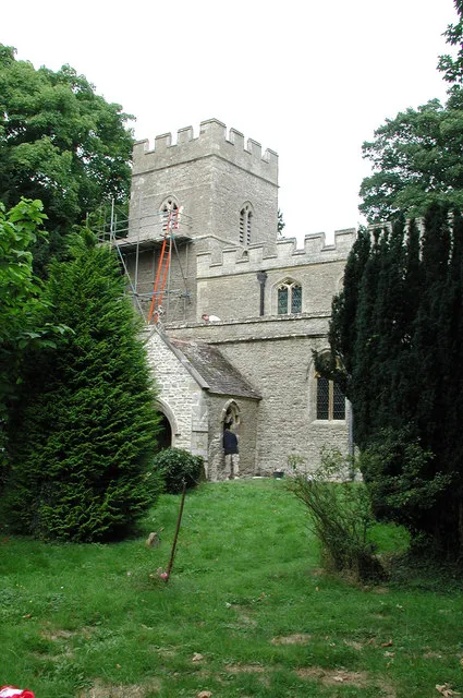
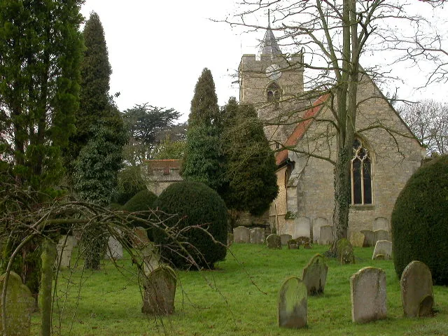
Most of the older buildings in the village have thatched roofs making for a quaint rural setting. The churchyard of the parish church of St Peter is considered by some as being one of the prettiest in the county. The Grade II-listed church dates from 1154 and includes a 14th-century window, bells dating from the 15th and 17th centuries, and a clock installed in 1774. It was closed to public worship in 2015, and in 2025, the church was put up for sale with planning permission for conversion into a three-bedroom home.
Sourced from Wikipedia under CC BY-SA 4.0.
- Coordinates
- 52.1161, -0.6105
- District
- Milton Keynes
- Parish
- Astwood
- Postcode
- MK16
- Parliamentary constituency
- Milton Keynes North
- Population
- 204
- Nearest railway station
- Kempston Hardwick — 7.8 km
Sources
- wikidata: Q1770559 (CC0)
- wikipedia: Astwood, Buckinghamshire (CC BY-SA 4.0)
- commons: The Old Swan - geograph.org.uk - 276598.jpg (CC BY-SA 4.0)
Other places nearby
Loading nearby places…
Nearby
 📷 3
📷 3Historic churches · West Midlands
St Mary's Church, Hardmead
St Mary's Church, Hardmead — Grade I listed church in Hardmead, Milton Keynes, Buckinghamshire, England, UK.
 📷 3
📷 3Manor houses · West Midlands
Chicheley Manor
Chicheley Manor — Grade II listed building-listed manor in england-west-midlands, United Kingdom.
 📷 3
📷 3Archaeological sites · West Midlands
St Martin’s Chapel ((Site Of)
St Martin’s Chapel ((Site Of) — a archaeological in england-west-midlands, United Kingdom.
 📷 3
📷 3Historic churches · West Midlands
Church of St Leonard, Stagsden
Church of St Leonard, Stagsden — Grade I listed church in Stagsden, Bedford, Bedfordshire, England, UK.
 📷 3
📷 3Memorials & monuments · West Midlands
North Crawley War Memorial
North Crawley War Memorial — Grade II listed building-listed memorial in england-west-midlands, United Kingdom.
 📷 3
📷 3Towns & cities · West Midlands
North Crawley
North Crawley — village and civil parish in Buckinghamshire, UK.
More towns in this region
 Flagship📷 3
Towns & cities · West Midlands
Adderbury
Adderbury — village and civil parish in Cherwell district, Oxfordshire, England.
 Flagship📷 3
Towns & cities · West Midlands
Admington
Admington — village in Warwickshire, England, UK.
 Flagship📷 3
Towns & cities · West Midlands
Aldington
Aldington — village in Worcestershire, United Kingdom.
 Flagship📷 5
Towns & cities · West Midlands
Anstey
Anstey — large village in Leicestershire, England.
Frequently asked questions
- Where is Astwood?
- Astwood is in the West Midlands, United Kingdom (postcode MK16), in the parish of Astwood.
- Is Astwood free to visit?
- Yes, Astwood is free to enter.
- How do I get to Astwood?
- The nearest railway station is Kempston Hardwick, about 7.8 km away. Drivers can navigate to postcode MK16.