Museums · North East England
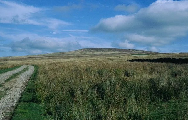
Arkengarthdale
Arkengarthdale in England North East, United Kingdom.

Gordon Hatton — CC BY-SA 2.0 via Wikimedia Commons licence
Plan your visit
- Typical visit
- 1.5 h–3 h
- Best time of year
- Year-round
- Family-friendly
- Limited wheelchair access
About
Arkengarthdale is a place of interest in England North East, United Kingdom — drawn from open-data sources for visitor reference. See the linked Wikipedia article for the full description.
Photo gallery
From the Wikipedia article
Arkengarthdale is a dale, or valley, on the east side of the Pennines in North Yorkshire, England. Running roughly north-west to south-east, it is the valley of the Arkle Beck, and is the northernmost of the Yorkshire Dales. It is a subsidiary dale to Swaledale, which it joins at Reeth. The history of the dale, its people, and farming, lead mining, and local crafts is displayed and documented in the Swaledale Museum in Reeth. On its way up the dale from Reeth the unclassified road crosses many other small streams and their catchments, such as Great Punchard Gill, Roe Beck, Annaside Beck, and William Gill. It passes through several small settlements: Raw, Arkle Town, Langthwaite (where a narrow back road leads to Booze), Eskeleth and Whaw. At Eskeleth Bridge another unclassified road forks north-east (towards Barnard Castle); this also joins a minor road running along the northern side of the dale to Whaw. Beyond Whaw is the most sparsely populated upper part of Arkengarthdale, which here runs roughly west–east. This area is one of the most northerly parts of the Yorkshire Dales National Park. Eventually the dale ends and the road reaches the Tan Hill Inn, the highest in England, just outside the Park, near the Pennine watershed. Beyond Tan Hill, the road divides again, heading westward to Brough, south to Keld and south-west to Kirkby Stephen. The moors on both sides of Arkengarthdale are used for the annual Scott Trial, a cross-country motorcycle endurance event. The Dale cuts through the eastern half of a major lead mining field and lead was extracted from the area for over a thousand years. Most of the mining structures have now disappeared leaving only the spoil heaps and the line of an 3,600-foot (1,100 m) long chimney from the site of the smelting mill. The current economy of the Dale depends on hill farming, grouse shooting and tourism. In 1989 Arkengarthdale (and Swaledale) were designated as a Barns and Walls Conservation Area.
Excerpt from Wikipedia under CC BY-SA 4.0. See the source article linked in Sources below.
Background
History
In the 19th century a lead ingot with the name Hadrian stamped on it was found, at Hurst, east of the dale. This find, which has been lost at the British Museum, as well as records of the Romans at Richmond using Brigantian slaves digging for lead, has led to the assumption that the Romans were mining lead in Arkengarthdale in the 2nd century. The large proportion of Viking names, Fagger Gill, Kitley Hill, Langthwaite and Whaw, indicates Viking settlement during the 10th century, probably arriving from the west. Arkil is a Viking name which leads to speculation that he was a local leader. However, despite its history pre-dating the Domesday Book, none of the settlements in the area appear…
Description
In 1800 the mines of Arkengarthdale were let for 21 years to a Newcastle company for a fixed rent rather than a percentage of the lead mined. The company, under its manager Frederick Hall, invested heavily in new technology. In 1804 they built a new smelting mill, 2 mi north of Langthwaite. It was octagonal in design, 110 ft by 75 ft, with a 36 ft diameter water wheel to drive the bellows. It had four flues and a timber roof. In 1824, the octagonal mill was replaced by the New Mill a few hundred yards away on the other side of the Tan Hill road. The New Mill was built by Easterby Hall & Co. for Ark & Darwent Mining Company. It had improved fire chamber design and a 33 ft water wheel, but…
Sourced from Wikipedia under CC BY-SA 4.0.
- Coordinates
- 54.4500, -2.0340
- District
- North Yorkshire
- Parish
- Arkengarthdale
- Postcode
- DL11 6RR
- Parliamentary constituency
- Richmond and Northallerton
Sources
- wikidata: Q3695727 (CC0)
- wikipedia: Arkengarthdale (CC BY-SA 4.0)
Other places nearby
Loading nearby places…
Nearby
 📷 5
📷 5Natural landmarks · North East England
Whaw
Whaw in England North East, United Kingdom.
 📷 3
📷 3Wildlife reserves · North East England
Arkle Beck Meadows, Whaw
Arkle Beck Meadows, Whaw in England North East, United Kingdom.
 📷 3
📷 3Mountains & hills · Yorkshire & the Humber
Hoove
Hoove — Named summit at 554 m.
 📷 3
📷 3Archaeological sites · North West England
Old Smelting Mill
Old Smelting Mill — a archaeological in england-north-west, United Kingdom.
 📷 3
📷 3Memorials & monuments · Yorkshire & the Humber
Fryingpan Stone
Fryingpan Stone — a memorial in england-yorkshire, United Kingdom.
📷 3Historic houses · North West England
Lead Flue
Lead Flue — a historic house in england-north-west, United Kingdom.
More museums in this region
 📷 3
📷 3Museums · North East England
Kirkleatham Museum
Kirkleatham Museum — museum in the Tees Valley, United Kingdom.
 📷 3
📷 3Museums · North East England
Staithes Museum
Staithes Museum — museum in Staithes, North Yorkshire, England, UK.
 📷 3
📷 3Museums · North East England
The Rum Story
The Rum Story — museum in Whitehaven, England.
 📷 4
📷 4Museums · North East England
Former Chapel School
Former Chapel School in England North East, United Kingdom.
Frequently asked questions
- Where is Arkengarthdale?
- Arkengarthdale is in North East England, in the United Kingdom — coordinates 54.4500°, -2.0340°.
- Is Arkengarthdale wheelchair accessible?
- Partially — OpenStreetMap notes limited wheelchair access at Arkengarthdale. Check ahead for specific facilities.