Towns & cities · East of England
Alburgh
Alburgh — village and civil parish in Norfolk, UK.

Wikimedia Commons contributors — see linked file page for photographer and licence licence
Plan your visit
- Typical visit
- 3 h–6 h
- Free entry
- Family-friendly
- Dog-friendly
About
Alburgh is a town, city, village or settlement in the United Kingdom. It covers approximately 6 km². Recent population estimates put it at around 349 people. Address: IP20. Wikidata describes it as: "village and civil parish in Norfolk, UK". Coordinates: 52.4339°, 1.3335°.
Photo gallery
Protected designations
- Area of Outstanding Natural Beauty: Suffolk Coast & Heaths
Designations sourced from Natural England open data under OGL v3.
From the Wikipedia article
Alburgh is a village and civil parish in the South Norfolk district of the English county of Norfolk. It is about 4 miles (6.4 km) north-east of Harleston and 16 miles (26 km) south of Norwich. The parish is on the border with Suffolk along the River Waveney.
Excerpt from Wikipedia under CC BY-SA 4.0. See the source article linked in Sources below.
Background
History
The earliest evidence of settlement in the parish is from the Mesolithic and Neolithic eras, with a number of flint tools having been recovered. A barrow dating from the Bronze Age was excavated in the 19th century, with human bones reportedly discovered. The village name, which is thought to mean "old mound or hill" or "mound or hill belonging to Alda", may derive from this. During the medieval period Holbrook Hall, a moated manor house, was built in the south of the parish. It was demolished in 1570 after Gawdy Hall was built further north. A series of earthworks remain. A number of buildings in the parish, including Alburgh Hall and Church Farm, date to the 16th century. Agriculture…
Sourced from Wikipedia under CC BY-SA 4.0.
- Coordinates
- 52.4339, 1.3335
- County
- Norfolk
- District
- South Norfolk
- Parish
- Alburgh
- Postcode
- IP20
- Parliamentary constituency
- Waveney Valley
- Population
- 349
Sources
- wikidata: Q1785146 (CC0)
- wikipedia: Alburgh (CC BY-SA 4.0)
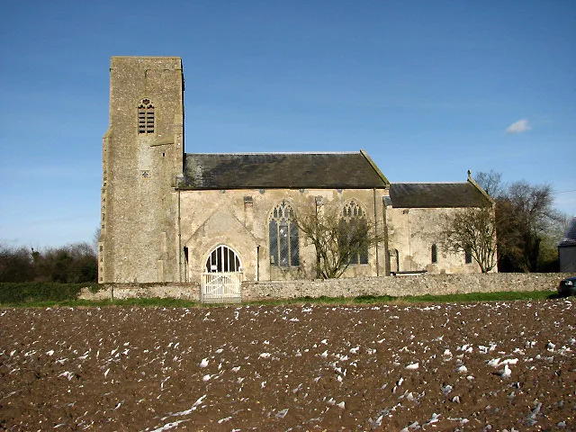
- commons: All Saints Church, Alburgh - geograph.org.uk - 384043.jpg (CC BY-SA 4.0)
Other places nearby
Loading nearby places…
Nearby
 📷 3
📷 3Memorials & monuments · East of England
Alburgh War Memorial
Alburgh War Memorial — Grade II listed building-listed memorial in england-east, United Kingdom.
 📷 3
📷 3Historic churches · East of England
Church of All Saints
Church of All Saints — Anglican church in Alburgh, Norfolk, England, UK.
 📷 3
📷 3Public art & sculpture · East of England
Alburgh Village Sign
Alburgh Village Sign — a public art in england-east, United Kingdom.
 📷 3
📷 3Public art & sculpture · East of England
Denton Village Sign
Denton Village Sign — a public art in england-east, United Kingdom.
 📷 3
📷 3Historic churches · East of England
Church of St Mary
Church of St Mary — church of Denton St Mary in South Norfolk, England, UK.
 📷 4
📷 4Historic bridges · East of England
Homersfield Bridge
Homersfield Bridge — Grade II* listed building-listed bridge in england-east, United Kingdom.
More towns in this region
 Flagship📷 3
Towns & cities · East of England
Aldeby
Aldeby — village and civil parish in Norfolk, UK.
 Flagship📷 5
Towns & cities · East of England
Ashill
Ashill — village and civil parish in the English county of Norfolk.
 Flagship📷 3
Towns & cities · East of England
Aslacton
Aslacton — village and civil parish in Norfolk, UK.
 Flagship📷 3
Towns & cities · East of England
Barford
Barford — village and civil parish in Norfolk, UK.
Frequently asked questions
- Where is Alburgh?
- Alburgh is in Norfolk, East of England, United Kingdom (postcode IP20), in the parish of Alburgh.
- Is Alburgh a protected site?
- Yes — Alburgh is part of the Suffolk Coast & Heaths National Landscape (AONB).
- Is Alburgh free to visit?
- Yes, Alburgh is free to enter.
- How do I get to Alburgh?
- Drivers can navigate to postcode IP20. It sits within the Waveney Valley parliamentary constituency.