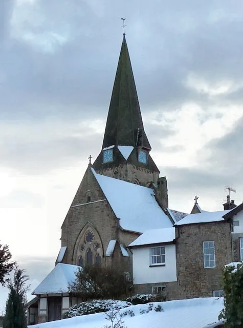
Historic churches · North West England
Abram, Greater Manchester
Abram is a village and electoral ward in the Metropolitan Borough of Wigan, Greater Manchester, England. It lies on flat land on the northeast bank of the Leeds and Liverpool Canal, 2 miles (3.2 km) w

David Dixon — CC BY-SA 2.0 via Wikimedia Commons licence
Plan your visit
- Typical visit
- 30 min–1 h
- Free entry
About
Abram is a village and electoral ward in the Metropolitan Borough of Wigan, Greater Manchester, England. It lies on flat land on the northeast bank of the Leeds and Liverpool Canal, 2 miles (3.2 km) west of Leigh, 3 miles (4.8 km) southeast of Wigan, and 14.5 miles (23 km) west of Manchester. Abram is a dormitory village with a population of 9,855. Historically part of Lancashire, Abram anciently formed a township and chapelry in the parish of Wigan and hundred of West Derby. Abram appears in an entry of an ancient survey of Lancashire in 1212 under the name "Edburgham". The urbanisation and development of Abram largely coincided with the Industrial Revolution. Abram is at the centre of a coal district, and industrial scale coal mining was introduced to Abram around the middle of the 19th century with the opening of several collieries. In 1911, Abram was described as "distinctly unpicturesque ... trees are in the minority, and stunted and blackened with smoke", with "collieries, pit-banks, and railway lines" as well as "much pasture land". The Maypole Colliery Disaster in 1908 resulted in 75 deaths and profoundly changed the character of the village. Abram's coal mining industry declined in the mid-20th century, but the village has continued to grow due to its position between Leigh, Manchester, Warrington and Wigan. To the south of the village lies Abram Flashes, a 39.6 hectares (97.9 acres) area of shallow wetlands and a Site of Special Scientific Interest. Abram has histor
Photo gallery
From the Wikipedia article
Abram is a village and electoral ward in the Metropolitan Borough of Wigan, Greater Manchester, England. It lies on flat land on the northeast bank of the Leeds and Liverpool Canal, 2 miles (3.2 km) west of Leigh, 3 miles (4.8 km) southeast of Wigan, and 14.5 miles (23 km) west of Manchester. Abram is a dormitory village with a population of 9,855. Historically part of Lancashire, Abram anciently formed a township and chapelry in the parish of Wigan and hundred of West Derby. Abram appears in an entry of an ancient survey of Lancashire in 1212 under the name "Edburgham". The urbanisation and development of Abram largely coincided with the Industrial Revolution. Abram is at the centre of a coal district, and industrial scale coal mining was introduced to Abram around the middle of the 19th century with the opening of several collieries. In 1911, Abram was described as "distinctly unpicturesque ... trees are in the minority, and stunted and blackened with smoke", with "collieries, pit-banks, and railway lines" as well as "much pasture land". The Maypole Colliery Disaster in 1908 resulted in 75 deaths and profoundly changed the character of the village. Abram's coal mining industry declined in the mid-20th century, but the village has continued to grow due to its position between Leigh, Manchester, Warrington and Wigan. To the south of the village lies Abram Flashes, a 39.6 hectares (97.9 acres) area of shallow wetlands and a Site of Special Scientific Interest. Abram has historic associations with traditional morris dancing.
Excerpt from Wikipedia under CC BY-SA 4.0. See the source article linked in Sources below.
Background
History
in 1908, profoundly affecting the village.]] The village name is recorded as Edburgham in 1212 and Adburgham in 1246. The form Abraham is found in the 16th century, and the current name of Abram in the 18th. The manor was probably part of the larger manor of Newton until it was granted to "Warine son of Godfrey" by Henry II who reigned 1154 1189. The family adopted the name of the settlement, and remained Lords of the Manor until the 17th century. The family was ruined by the English Civil War, in which they supported the Royalists. When the last in male line of the Abraham family died in the 17th century, possession of the manor passed through many hands, and the title of Lord of the Manor…
Sourced from Wikipedia under CC BY-SA 4.0.
- Coordinates
- 53.5080, -2.5880
- District
- Wigan
- Parish
- Wigan, unparished area
- Postcode
- WN2 5XH
- Parliamentary constituency
- Makerfield
Sources
- wikipedia: Abram, Greater Manchester (CC BY-SA 4.0)
Other places nearby
Loading nearby places…
Nearby
 📷 3
📷 3Memorials & monuments · North West England
Abram Memorial
Abram Memorial — a memorial in england-north-west, United Kingdom.
 📷 3
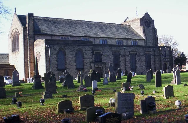
📷 3Historic churches · North West England
St John the Evangelist's Church, Abram
St John the Evangelist's Church, Abram — church in United Kingdom.
 📷 3
📷 3Historic bridges · North West England
Dover Bridge
Dover Bridge is a historic bridge in the United Kingdom.
 📷 3
📷 3Public art & sculpture · North West England
Viridor Wood Sculptures
Viridor Wood Sculptures — a public art in england-north-west, United Kingdom.
 📷 3
📷 3Theatres · North West England
Palace Picture House
Palace Picture House in England North West, United Kingdom.
 📷 5
📷 5Historic churches · North West England
Platt Bridge
Platt Bridge is a settlement in the Metropolitan Borough of Wigan, Greater Manchester, England, 2 miles (3.2 km) south of Wigan town centre along the spine of the A573 road. Historically part of the H
More places in this region
 📷 3
📷 3Historic churches · North West England
All Hallows Church, Great Mitton
All Hallows Church, Great Mitton — church in the village of Great Mitton, Lancashire, England, UK.
 📷 3
📷 3Historic churches · North West England
All Saints Church, Barnacre
All Saints Church, Barnacre — grade II listed church in Barnacre-with-Bonds, Wyre, Lancashire, England, UK.
 📷 3
📷 3Historic churches · North West England
All Saints Church, Becconsall
All Saints Church, Becconsall — church in United Kingdom.
 📷 3
📷 3Historic churches · North West England
All Saints Church, Burton in Lonsdale
All Saints Church, Burton in Lonsdale — church in Burton in Lonsdale, North Yorkshire, England, UK.
Frequently asked questions
- Where is Abram, Greater Manchester?
- Abram, Greater Manchester is in North-West England, United Kingdom (postcode WN2 5XH), in the parish of Wigan, unparished area.
- Is Abram, Greater Manchester free to visit?
- Yes, Abram, Greater Manchester is free to enter.
- How do I get to Abram, Greater Manchester?
- Drivers can navigate to postcode WN2 5XH. It sits within the Makerfield parliamentary constituency.