Towns & cities · Scottish Highlands
Aberlour
Also known as: Obar Lobhair
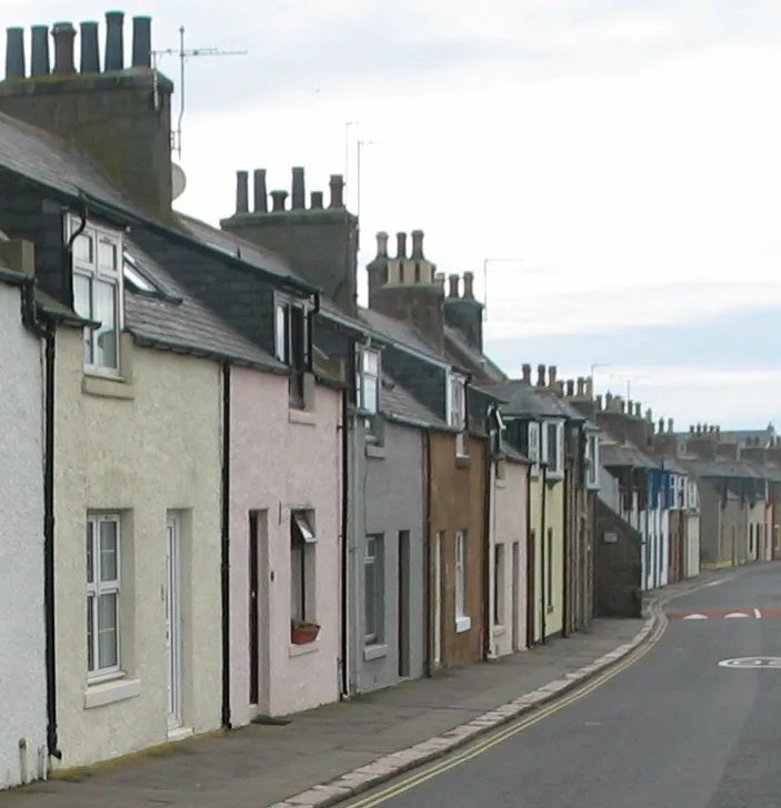
Aberlour — village in Moray, Scotland, UK.

Wikimedia Commons contributors — see linked file page for photographer and licence licence
Plan your visit
- Typical visit
- 3 h–6 h
- Nearest railway station
- Dufftown · 5.4 km
- Free entry
- Family-friendly
- Dog-friendly
About
Aberlour is a town, city, village or settlement in the United Kingdom. Recent population estimates put it at around 1,050 people. Address: AB38 9xx. Wikidata describes it as: "village in Moray, Scotland, UK". Coordinates: 57.4746°, -3.2168°.
Photo gallery
From the Wikipedia article
Aberlour (; Scottish Gaelic: Obar Lobhair) is a town in Moray, Scotland, 12 miles (20 km) south of Elgin on the road to Grantown. The Lour burn is a tributary of the River Spey, and it and the surrounding parish are both named Aberlour, but the name is more commonly used in reference to the village which straddles the stream and flanks the Spey – although the full name of the village is Charlestown of Aberlour.
Excerpt from Wikipedia under CC BY-SA 4.0. See the source article linked in Sources below.
Background
History
A site noted as Abirlaur is shown in this location on maps in Joan Blaeu's Atlas of Scotland, from 1654. The current village, Charlestown of Aberlour, was "founded by Charles Grant of Elchies in 1812 – with the name of Charlestown of Aberlour after his son Charles." It is commonly referred to simply as Aberlour. A grant of land from Charles Grant senior feued 100 plots along the south bank of the river and saw the start of the High Street (formerly Main Street) and parish church. The three locations are close enough in definition for there to be little distinction between them. The village was granted its feu charter in 1814 and began to operate its own markets. Whisky was a major industry…
Sourced from Wikipedia under CC BY-SA 4.0.
- Coordinates
- 57.4746, -3.2168
- District
- Moray
- Postcode
- AB38 9xx
- Parliamentary constituency
- Moray West, Nairn and Strathspey
- Population
- 1,050
- Nearest railway station
- Dufftown — 5.4 km
- Official site
- www.speyside.moray.org
Sources
- wikidata: Q1010405 (CC0)
- wikipedia: Aberlour (CC BY-SA 4.0)
- commons: Aberlour Highland March 2025.jpg (CC BY-SA 4.0)
Other places nearby
Loading nearby places…
Nearby
 📷 5
📷 5Historic churches · Scottish Highlands
St Margaret's Episcopal Church and Burial Ground, Aberlour
St Margaret's Episcopal Church and Burial Ground, Aberlour — category A listed building-listed church in scotland-highlands, United Kingdom.
📷 3Memorials & monuments · Scottish Highlands
Old Boys of Aberlour Orphanage War Memorial
Old Boys of Aberlour Orphanage War Memorial — a memorial in scotland-highlands, United Kingdom.
 📷 3
📷 3Historic houses · Scottish Highlands
West Lodge, Aberlour House
West Lodge, Aberlour House — lodge house in Moray, Scotland, UK.
 📷 5
📷 5Beaches · Scottish Highlands
Sandy Hole
Sandy Hole is a beach in the United Kingdom.
 📷 3
📷 3Memorials & monuments · Scottish Highlands
Aberlour 200th Anniversary memorial
Aberlour 200th Anniversary memorial — a memorial in scotland-highlands, United Kingdom.
 📷 3
📷 3Memorials & monuments · Scottish Highlands
Aberlour War Memorial
Aberlour War Memorial — a memorial in scotland-highlands, United Kingdom.
More towns in this region
 Flagship📷 3
Towns & cities · Scottish Highlands
Cruden Bay
Cruden Bay — village in Aberdeenshire, Scotland, UK.
 Flagship📷 3
Towns & cities · Scottish Highlands
Inverness
Inverness — city in the Highlands of Scotland, United Kingdom.
 Flagship📷 3
Towns & cities · Scottish Highlands
Kyle of Lochalsh
Kyle of Lochalsh — village in Highland, Scotland, UK.
 📷 4
📷 4Towns & cities · Scottish Highlands
Aberchirder
Aberchirder — village in Aberdeenshire, Scotland, UK.
Frequently asked questions
- Where is Aberlour?
- Aberlour is in the Scottish Highlands, United Kingdom (postcode AB38 9xx).
- Is Aberlour free to visit?
- Yes, Aberlour is free to enter.
- How do I get to Aberlour?
- The nearest railway station is Dufftown, about 5.4 km away. Drivers can navigate to postcode AB38 9xx.