Mountains & hills · Scottish Highlands
A' Chràileag
Also known as: A' Chralaig
A' Chràileag — Named summit at 1120 m.

Wikimedia Commons contributors — see linked file page for photographer and licence licence
Plan your visit
- Typical visit
- 3 h–8 h
- Best time of year
- Late spring – early autumn (May–Oct)
- Free entry
- Dog-friendly
About
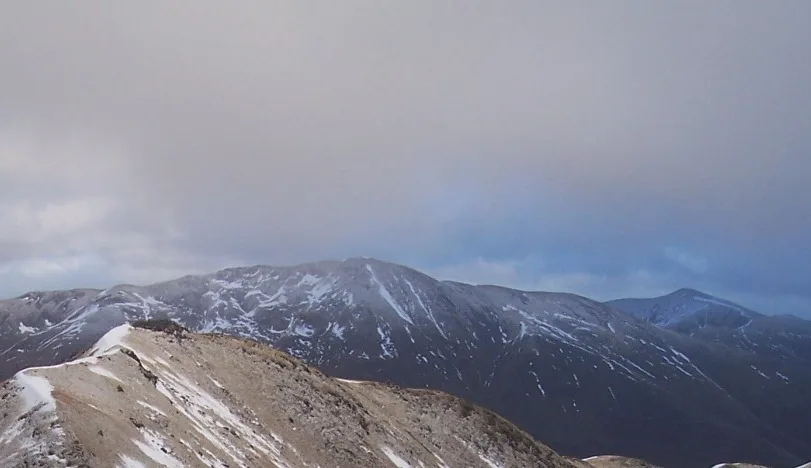
A' Chràileag is a named summit in the United Kingdom. Wikidata describes it as: "Named summit at 1120 m.". Coordinates: 57.1842°, -5.1548°.
Photo gallery
From the Wikipedia article
A' Chralaig (Scottish Gaelic: A' Chràileag) is a mountain in the Northwest Highlands of Scotland, north of Loch Cluanie and south of Glen Affric. It is a Munro with a height of 1,120 metres (3,670 ft). It is the highest peak along Glen Shiel and can be easily climbed from the Cluanie Inn on the A87. The eastern slopes of the mountain, are owned by the Forestry Commission and are part of the Kintail National Scenic Area. Despite being the highest peak on the ridge, it is considered less interesting than the route over Stob Coire na Cràlaig to the nearby Mullach Fraoch-choire. These two peaks may be combined with the neighbouring peaks of Sgurr nan Conbhairean and Sail Chaorainn to make the so-called "Cluanie Horseshoe", although no path connects A' Chràlaig with the peaks to the east.
Excerpt from Wikipedia under CC BY-SA 4.0. See the source article linked in Sources below.
- Coordinates
- 57.1842, -5.1548
- Address
- Highland, Scotland
- Official site
- www.walkhighlands.co.uk
Sources
- osm: n255703626 (ODbL)
- wikipedia: A' Chràlaig (CC BY-SA 4.0)
- commons: AChralaig2 06-07 048.jpg (CC BY-SA 4.0)
Other places nearby
Loading nearby places…
Nearby
 📷 3
📷 3Natural landmarks · Scottish Highlands
A' Chràlaig
A' Chràlaig — 1120m high mountain in Highland, Scotland, UK.
 📷 3
📷 3Mountains & hills · Scottish Highlands
A'Chralaig - Stob Coire na Cralaig
A'Chralaig - Stob Coire na Cralaig — a mountain in scotland-highlands, United Kingdom.
 📷 3
📷 3Natural landmarks · Scottish Highlands
Am Bàthach
Am Bàthach — mountain in Highland, Scotland, UK.
 📷 3
📷 3Mountains & hills · Scottish Highlands
Am Bàthach
Am Bàthach — Named summit at 798 m.
 📷 3
📷 3Mountains & hills · Scottish Highlands
Mullach Fraoch-choire
Mullach Fraoch-choire — Named summit at 1102 m.
 📷 3
📷 3Mountains & hills · Scottish Highlands
Sgurr nan Conbhairean - Drochaid an Tuill Easaich
Sgurr nan Conbhairean - Drochaid an Tuill Easaich — a mountain in scotland-highlands, United Kingdom.
More mountains in this region
 📷 3
📷 3Mountains & hills · Scottish Highlands
A' Bhuidheanach Bheag
A' Bhuidheanach Bheag — Named summit at 936 m.
 📷 3
📷 3Mountains & hills · Scottish Highlands
A' Chailleach
A' Chailleach — Named summit at 997 m.
 📷 3
📷 3Mountains & hills · Scottish Highlands
A' Chailleach
A' Chailleach — Named summit at 930 m.
 📷 3
📷 3Mountains & hills · Scottish Highlands
A' Chaoirnich
A' Chaoirnich — Named summit at 875 m.
Frequently asked questions
- Where is A' Chràileag?
- A' Chràileag is in Scottish Highlands, in the United Kingdom — coordinates 57.1842°, -5.1548°.
- Is A' Chràileag free to visit?
- Yes — admission to A' Chràileag is free.